Drone LiDAR Case Study: Flawless Urban Breaklines in Denver with the ROCK Ultra
Aug 04, 2025
For years, land surveyors have been forced to make a compromise. The choice was either an ultra-high-end LiDAR system with a six-figure price tag or an affordable system that sacrificed range, accuracy, and data quality. This meant that for most firms, true top-tier performance was simply out of reach. That era of compromise is over.
Enter the ROCK Ultra.
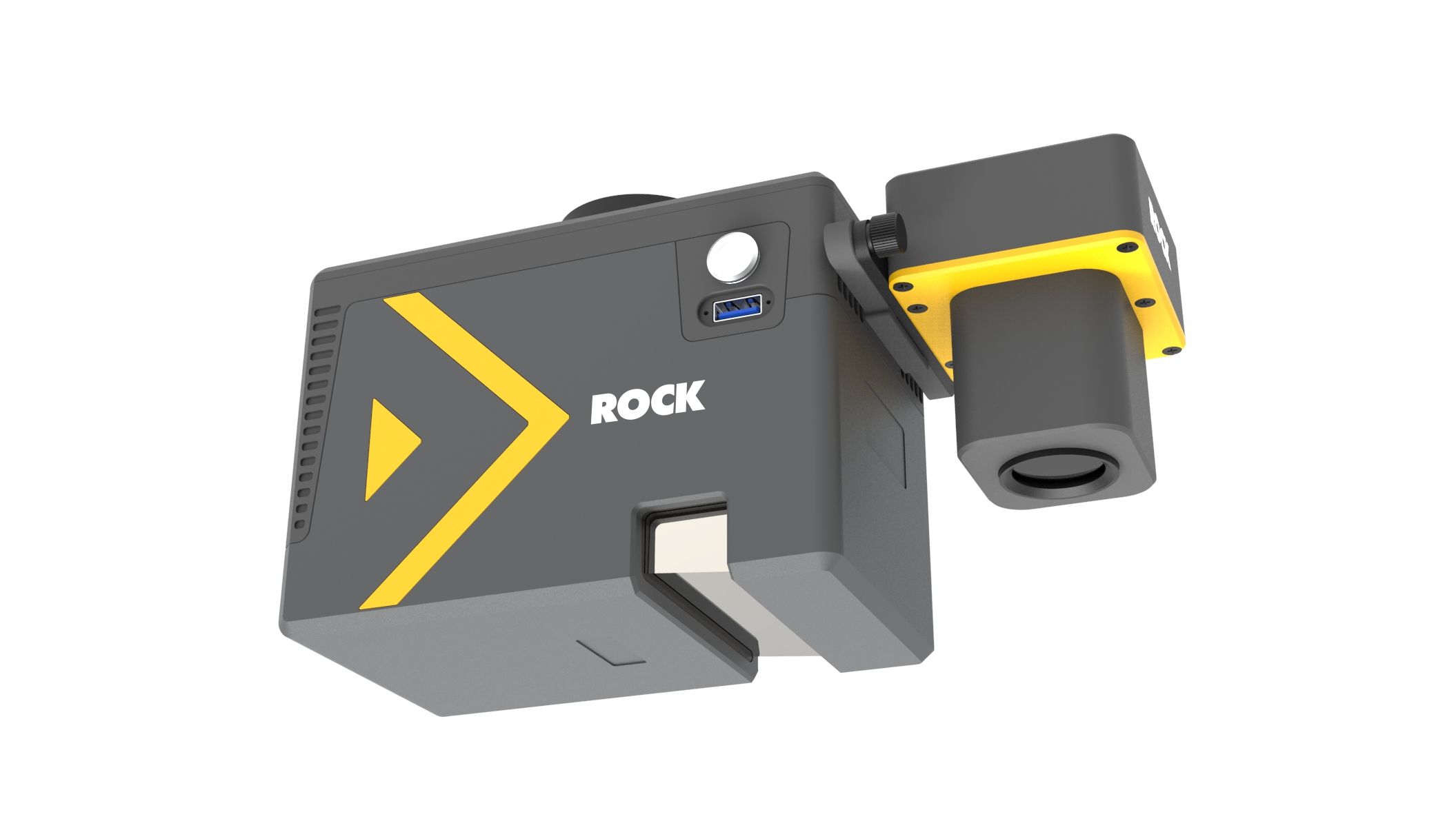
This isn't just an iteration; it's a revolution in a box. We engineered the ROCK Ultra to be the one tool that rules them all for the modern surveyor—a system that delivers the tactical-grade accuracy and long-range performance of elite systems at a price point that fundamentally changes the ROI calculation for your business. It’s designed to be the definitive solution for nearly any project you can throw at it.
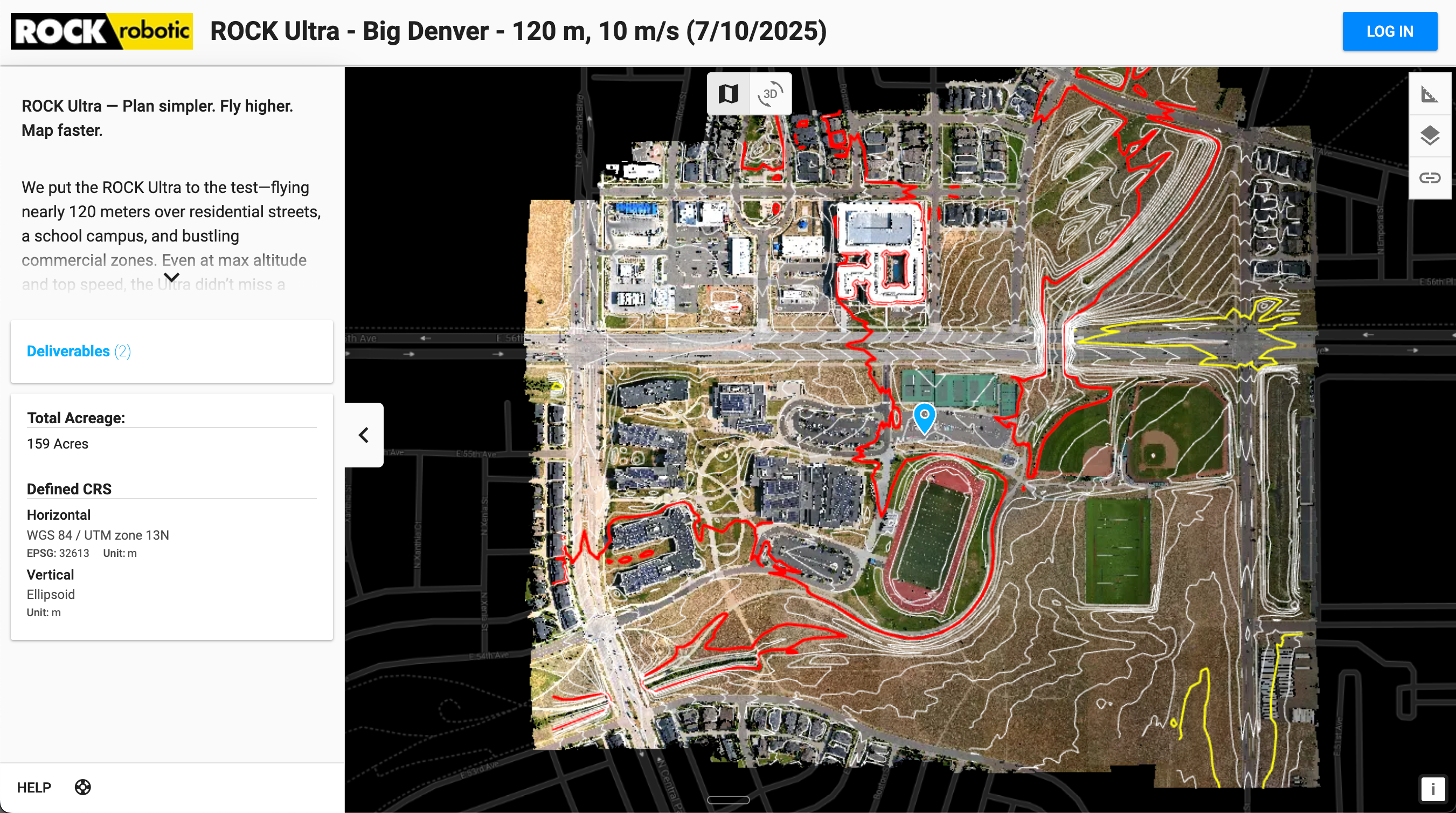
But claims are easy to make. We believe in proof. To demonstrate the Ultra's power, we put it to the ultimate test on a complex, 159-acre urban site in Denver, a scenario filled with the exact challenges that cause daily frustrations for survey crews nationwide. This is not just a case study; this is the evidence of what happens when you remove compromise from the equation.
The Ground-Truth Dilemma: The Daily Struggles of Urban Surveying
Before we show you the results, let's revisit the familiar pains of this kind of project. For any surveyor tasked with mapping an urban corridor, the mission is a battle against risk, inefficiency, and time.
The High-Traffic Tightrope
The primary challenge is capturing data along active roadways. To get an accurate road crown, lane markings, and curb returns, traditional methods require "boots on the ground," which means:
- Extreme Safety Risks: Field crews work inches away from live traffic, a constant and stressful danger.
- Logistical Nightmares: The process of obtaining permits, implementing traffic control with cones and flaggers, and disrupting the public can take days of planning and add thousands in overhead cost before a single point is even collected.
- A Glacial Pace: Data collection itself is painfully slow. Using a total station or terrestrial scanner, a crew might spend an entire day capturing just a segment of a roadway, meticulously collecting discrete points and fighting obstructions from passing vehicles.
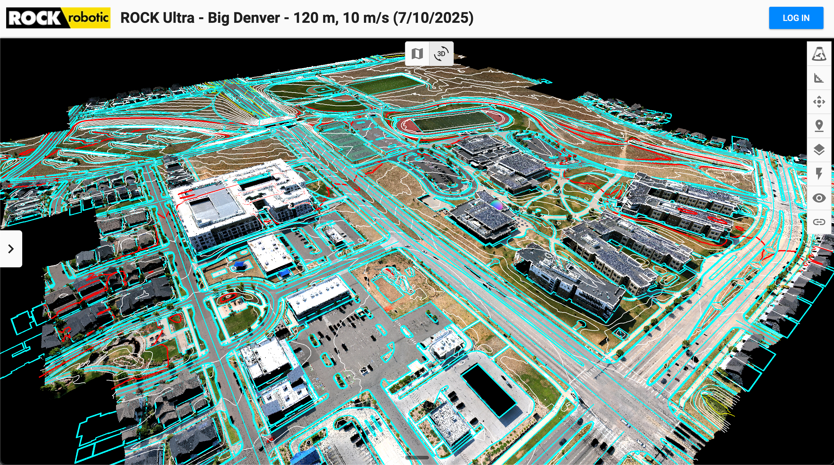
This Denver site, with its mix of busy streets, a school campus, and commercial lots, was the perfect arena to prove there is a better, safer, and profoundly faster way to collect this essential data with drone LiDAR.
The Mission: High-Altitude Precision Over Denver
Our objective was clear: use the ROCK Ultra to fly high and fast over the 159-acre site and produce a point cloud so clean and accurate that it could be used for the most demanding engineering deliverables. In one 25-minute flight at 120 m (400 ft) AGL, we captured what would have taken a field crew days to survey, all without ever stepping foot near a moving vehicle.
The ROCK Ultra Advantage: The Technology That Makes the Difference
This level of performance stems from a combination of superior components, delivering a capability previously unheard of at this price point.
- Tactical-Grade IMU (0.006° Accuracy): This is the heart of data quality. This incredibly precise IMU eliminates strip misalignment, giving you an exceptionally clean point cloud right out of the box. For surveyors, this means drastically less time spent on manual data cleanup in the office. The clean data allows for the immediate and clear identification of sharp features like the top and bottom of a curb.
- Long-Range 1550nm Laser & ≥7 Returns: The Ultra’s powerful, eye-safe laser excels where other systems falter, providing superior performance over dark asphalt and in bright sunlight. More importantly, its ability to capture 7 or more returns per pulse is a game-changer for getting a flawless bare-earth model, even in areas with low-lying vegetation.
- Focused 90° Field of View (FOV): The ROCK Ultra’s intelligent design directs all 1,000,000 points per second downward onto your project area, creating a far denser and more useful point cloud on the ground and ensuring no detail is missed.
- Unprecedented Value: The combination of these elite components in one lightweight, affordable package is what makes the ROCK Ultra a true market disruptor. It democratizes access to technology that was once reserved for only the largest firms, enabling surveyors of all sizes to compete on a new level.
The ROCK Ecosystem: A Workflow Built for Flexibility and Speed
A powerful sensor is only part of the solution. The true magic happens when its pristine data enters the ROCK Robotic ecosystem, which is designed to be as flexible as it is powerful. You have the choice: process it yourself or let us accelerate your timeline.
Option 1: The Power is in Your Hands (In-House Processing)
The ROCK Ultra delivers a beautiful, georeferenced .laz point cloud file ready for your team. For survey firms with dedicated CAD technicians and established drafting workflows, this is the perfect solution. You can:
- Process the raw data through ROCK Desktop to generate your colorized, calibrated point cloud.
- Import the .laz file directly into your preferred CAD or GIS software (like Civil 3D, Carlson, or Trimble Business Center).
- Maintain full control over your drafting standards, layer management, and final QA/QC process.
This flexibility ensures that the ROCK Ultra seamlessly integrates into your existing operations, acting as a powerful front-end data collection engine for your expert team.
Option 2: The Accelerator (ROCK Pro Services)
What if your team is at capacity? What if you need to turn a project around in days, not weeks? This is where ROCK Pro Services becomes your on-demand force multiplier. It's an optional service designed to transform your raw data into final, client-ready deliverables with incredible speed.
For the 159-acre Denver project, we put this service to the test. From the moment the point cloud was uploaded to the ROCK Cloud, our team delivered the final, fully drafted breaklines in a CAD-ready format in under 48 hours.
This incredible turnaround isn't just about our team's skill; it's a direct result of the exceptional data quality they start with. The cleaner the data, the faster the extraction.
“Seeing the consistently crisp curbs from the ROCK Ultra at 120 m and 10 m/s was a game-changer. Each point reaffirmed the ROCK Ultra’s quality and reliability, making the extraction of clean breaklines for our clients incredibly efficient.”
— Jamie Lackner, ROCK Pro Services Manager
This synergy between elite hardware and expert services is what allows you to take on more concurrent projects, meet aggressive deadlines, and free up your internal staff to focus on client relations and new business development.
The Result: The One Tool for the Modern Surveyor
The Denver project successfully demonstrated that the ROCK Ultra is the single, versatile tool that empowers survey firms to do more, with less risk and higher profitability. It's the end of compromise between price and performance. It is the tool that allows you to confidently say "yes" to more projects, knowing you have the power, accuracy, and workflow flexibility to deliver superior results, every single time.
ROCK Ultra's Big Denver Project visualized in the ROCK Cloud
Stay tuned for our next project showcase. In the meantime, contact our team to see how the ROCK Ultra can redefine what’s possible for your business.
Sales: +1 (720) 706-8648 | Email: hello@rockrobotic.com | Visit rockrobotic.com/ultra