ROCK SLAM
Centimeter-Accurate 3D Mapping.
No GPS Required.
Create professional-grade 3D point clouds with 1-2cm relative accuracy in any environment. Indoor spaces, dense forests, urban canyons—ROCK SLAM maps where satellites can\'t reach.
Professional 3D Reality Capture Without Limits
SLAM (Simultaneous Localization and Mapping) technology builds accurate 3D maps while tracking position—no GPS satellites needed.
1-2cm Relative Accuracy
Professional-grade point clouds with centimeter-level precision. Perfect for as-built documentation, BIM verification, and engineering surveys.
GCP & GPS Integration
Add ground control points in ROCK Desktop to achieve absolute accuracy. Optional GPS receiver enables automatic georeferencing when outdoors.
Complete Data Fusion
Merge SLAM data with aerial LiDAR seamlessly in ROCK Cloud. Create unified models combining indoor, outdoor, and aerial perspectives.
Works with Your Existing R3 Hardware
Transform your ROCK R3 or R3 Pro aerial LiDAR into a powerful SLAM scanner. Same sensor, same software workflow—just add a SLAM DOCK for handheld or mobile mapping.
Where ROCK SLAM Excels
Map complex environments with confidence. SLAM technology thrives where traditional methods struggle.
Indoor Mapping
Complete building interiors, warehouses, factories—capture every detail for as-builts and BIM.
Under Canopy
Dense forest floors, tree trunks, understory—map what aerial LiDAR misses.
Industrial Sites
Complex piping, machinery, confined spaces—document assets with centimeter precision.
Emergency Response
Crime scenes, disaster areas, hazardous zones—rapid 3D documentation for safety.
Understanding SLAM Technology
SLAM stands for Simultaneous Localization and Mapping—a breakthrough technology that creates maps while tracking position in real-time
LiDAR Sensor
Continuously emits laser pulses to measure distances and build 3D point clouds
IMU Tracking
High-frequency IMU tracks rotation, acceleration, and orientation continuously
SLAM Algorithm
Matches geometric features to correct drift and optimize the entire trajectory
Loop Closure: The Secret to Centimeter Accuracy
When you return to a previously scanned area, our algorithm recognizes the unique geometric signature and uses this "loop" to perform global optimization, distributing and correcting any accumulated error across the entire trajectory.
Result: 1-2cm relative accuracy throughout your entire scan
Complete Your Reality Capture Workflow
ROCK SLAM fills the gaps that aerial LiDAR leaves behind, creating a complete 3D model of your project.
Aerial LiDAR Captures
- Large-scale topography
- Building rooftops
- Open terrain
- Vegetation canopy
ROCK SLAM Completes
- Building interiors
- Complex facades & overhangs
- Under-canopy detail
- GPS-denied areas
One Sensor. One Workflow. Complete Coverage.
Use the same R3 hardware for both aerial and SLAM capture. Process everything in ROCK Desktop and Cloud.
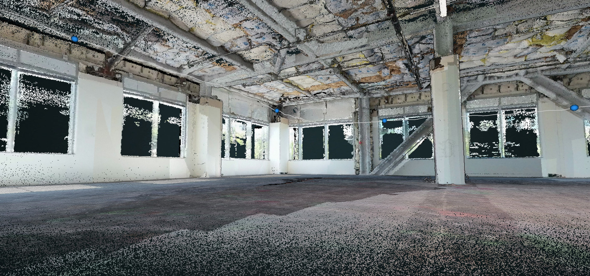
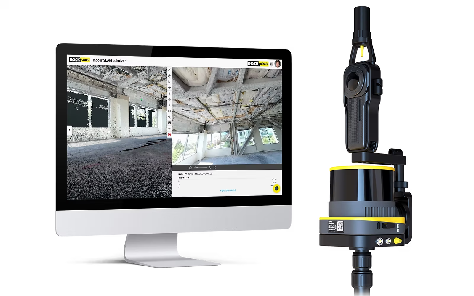
See Your Data in True Color
SLAM DOCK v2 with integrated 360° camera doesn't just capture geometry—it paints your point clouds with photorealistic color, making interpretation and documentation intuitive.
- Automatic colorization during processing
- Identify materials and surfaces instantly
- Export for CAD and BIM workflows
The ROCK SLAM Hardware Ecosystem
Flexible platforms powered by industry-leading R3 series LiDAR scanners
The Classic Handheld Workhorse
Robust and reliable platform for capturing high-quality, non-colorized 3D SLAM data.
- Secure mount for R3 or R3 Pro units
- Ergonomic telescoping pole design
- 4-6 hours continuous scanning
Best For: Interior building mapping, stockpile volumetrics, and geometric-only requirements
 SLAM DOCK v2
The Next-Generation Multi-Tool
Advanced platform with 360° camera, optional GPS, and versatile mounting options.
- Integrated Insta360 X5 for full-color point clouds
- Optional GNSS for automatic georeferencing
- Vehicle mount compatible for mobile mapping
Best For: Professional surveys requiring color, georeferencing, and visual documentation
Powerful Features for Complete Control
Everything you need to capture and process ground-level reality
SLAM Algorithm
Proprietary algorithm fuses LiDAR, IMU, and optional GPS data for accurate positioning without satellites
360° Color Capture
Integrated Insta360 X5 camera provides full-color point clouds and immersive photo spheres
Hybrid GPS-SLAM
Automatic georeferencing when GPS is available, seamless transition to pure SLAM indoors
Loop Closure
Intelligent drift correction by recognizing previously scanned areas for superior accuracy
Extended Runtime
4-6 hours of continuous scanning on a single charge for large-scale projects
Data Fusion
Merge SLAM data with aerial LiDAR in ROCK Cloud for complete project models
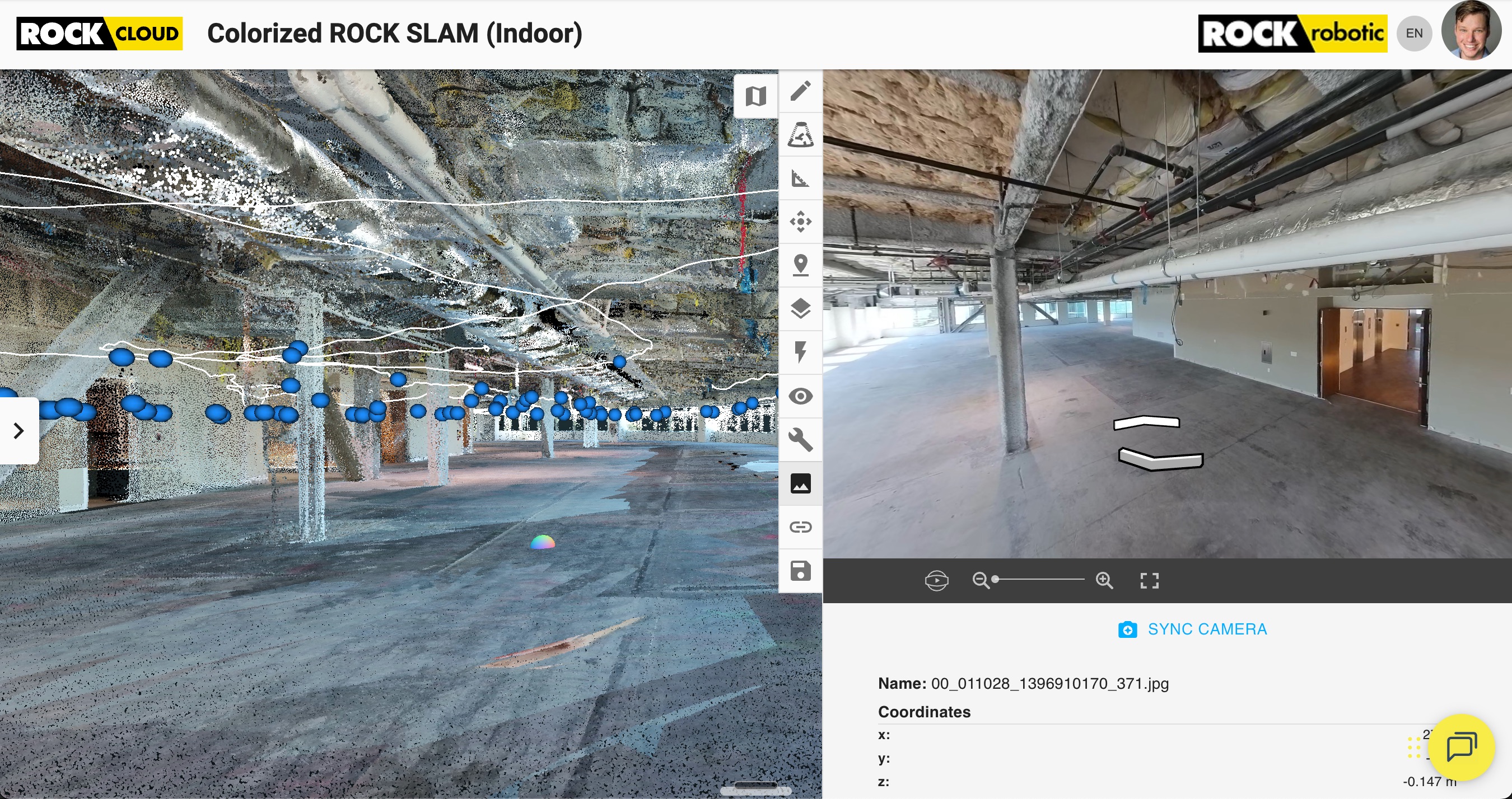
Immersive Photo Spheres in ROCK Cloud
Go beyond point clouds. SLAM DOCK v2 captures synchronized 360° imagery that transforms into interactive photo spheres in ROCK Cloud.
Virtual Site Visits
Click anywhere on the scan path to jump into a 360° view of that exact location
Visual Inspections
Measure, annotate, and document conditions with photographic context
Colorized Point Clouds
Automatically apply photorealistic colors to your entire SLAM dataset
Seamless Software Integration
ROCK Desktop
Process raw SLAM data with our proprietary algorithm
- Custom ROCK SLAM algorithm processing
- Add GCPs and recompute for absolute accuracy
- GNSS integration for drift mitigation
- Photo sphere extraction and synchronization
ROCK Cloud
Visualize, analyze, and deliver your SLAM data
- 3D colorized point cloud visualization
- Interactive 360° photo sphere walkthroughs
- Merge with aerial LiDAR data seamlessly
- Order professional deliverables
Field Operations Best Practices
Initialization
Hold still for 30 seconds aimed at a geometrically complex scene
Movement
Walk at a consistent, slow pace (~1 m/s) with smooth, deliberate turns
Loop Closures
Return to previously scanned areas every 60-120 meters to combat drift
Feature Awareness
In empty hallways, walk in zig-zag patterns to provide geometric variety
Pro Tip: Plan Your Route
Before starting, walk the intended path. Ensure all doors are open and the route is clear of obstacles to maintain continuous, uninterrupted scanning.
Industry Applications
Versatile solutions for multiple industries and use cases
Architecture & AEC
As-Built Documentation
Quickly create accurate 3D models of existing conditions for renovation and BIM projects with high-density colorized point clouds.
Land Surveying
ALTA Surveys & Topography
Capture building interiors and under-canopy ground truth that aerial data misses. Hybrid GPS-SLAM ensures georeferenced data.
Asset Management
Industrial Plants & Utilities
Document complex piping, machinery, and electrical infrastructure in tight spaces with handheld portability.
Public Safety
Forensics & Pre-Planning
Rapidly map crime scenes or create 3D models of critical infrastructure with immersive photo sphere walkthroughs.
Complete SLAM Solutions
Choose the package that fits your needs and budget
SLAM Starter
Essential SLAM mapping
- • R3 V2 LiDAR
- • SLAM DOCK v1
- • ROCK Desktop SLAM
- • ROCK Cloud Business
SLAM Professional
Complete colorized SLAM
- • R3 Pro V2 LiDAR
- • SLAM DOCK v2
- • 360° Camera Integration
- • ROCK Desktop SLAM
- • ROCK Cloud Business
SLAM Enterprise
Aerial + SLAM + Mobile
- • R3 Pro V2 LiDAR
- • SLAM DOCK v2 + GNSS
- • Mobile Mount
- • All Processing
- • Enterprise Support
All packages include 12-month warranty, ROCK Support, Cloud Business Plan, Desktop processing, and Academy training for up to 6 team members.
Capture Everything. Miss Nothing.
Stop delivering fragmented data. Start delivering a single, complete, and authoritative source of truth with ROCK SLAM.
Contact our team for pricing and package details