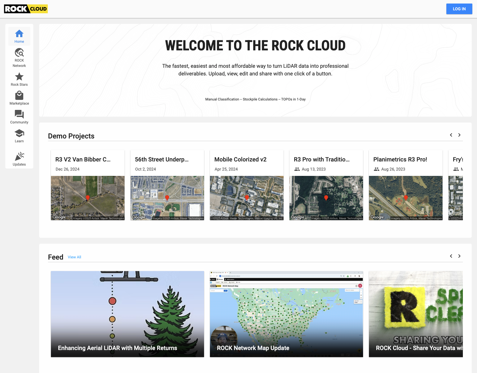
Turn Raw LiDAR Data into Professional Deliverables. Instantly.
The ROCK Cloud is your all-in-one platform to view, process, analyze, and share your data with clients.Order survey-grade CAD deliverables, powered by AI, with a single click.
Stop Wrestling with Your Data. Start Delivering Results.
Massive point clouds, complex software, and endless manual drafting can bring your projects to a halt.Traditional workflows are slow, expensive, and require powerful desktop computers that can't keep up.
Slow Desktop Processing
Desktop computers struggle with massive point clouds
Fragmented Software
Multiple tools and licenses for different tasks
Manual CAD Drafting
Days of tedious manual linework extraction
The All-In-One Platform Built for Surveyors, by Surveyors.
We built the ROCK Cloud to eliminate these bottlenecks. It's a single, powerful hub that takes your LiDAR data from field to finish. Process, analyze, and generate client-ready deliverables from anywhere, on any device.No downloads, no complex installations—just results.
Powerful Features & Tools for Complete Control
Everything you need to transform raw data into professional deliverables
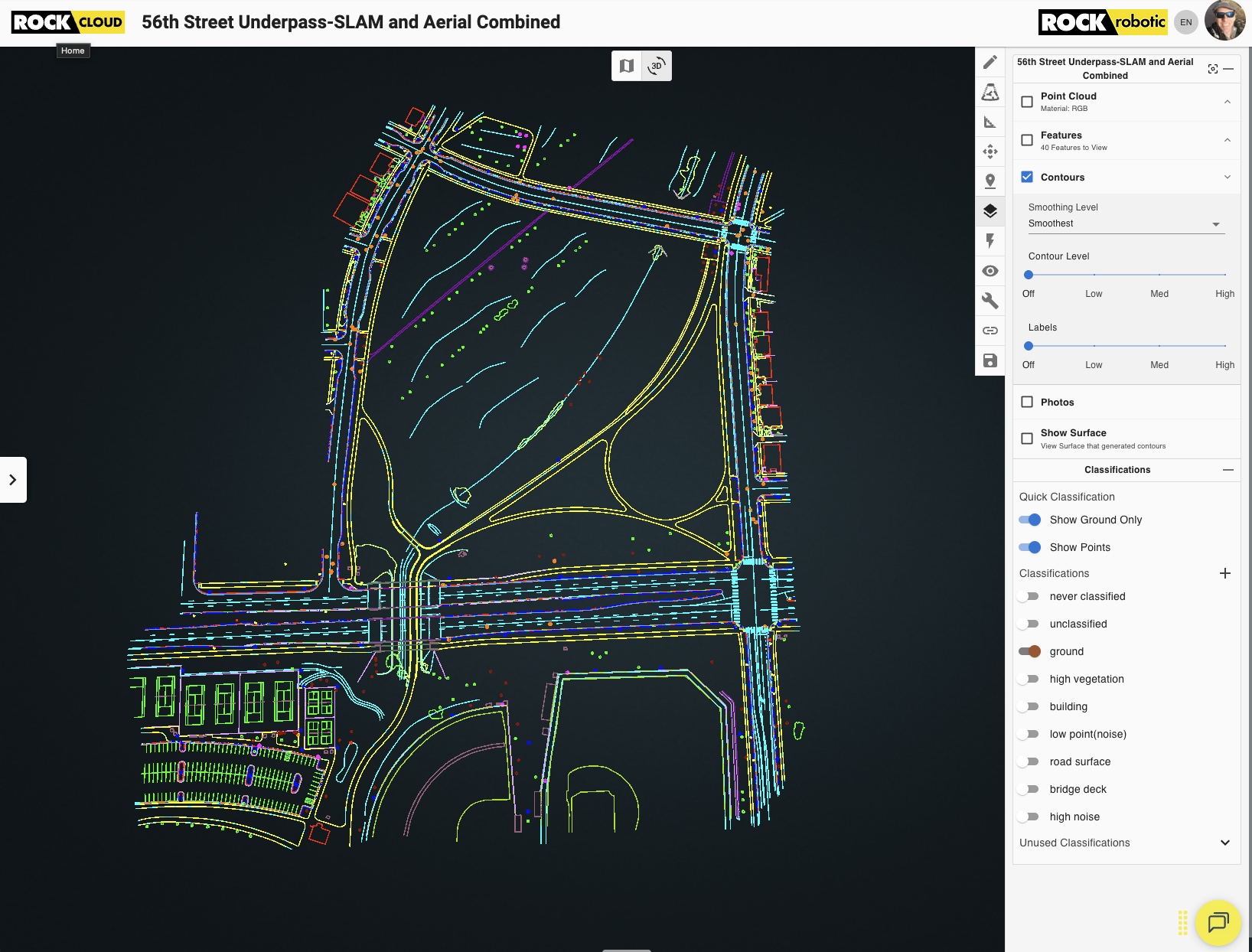
Real-Time Editing & Classifications
Easily classify your raw LiDAR data. Delete and clean up stray points, classify buildings, streets, vegetation, and more. All in real-time on the ROCK Cloud.
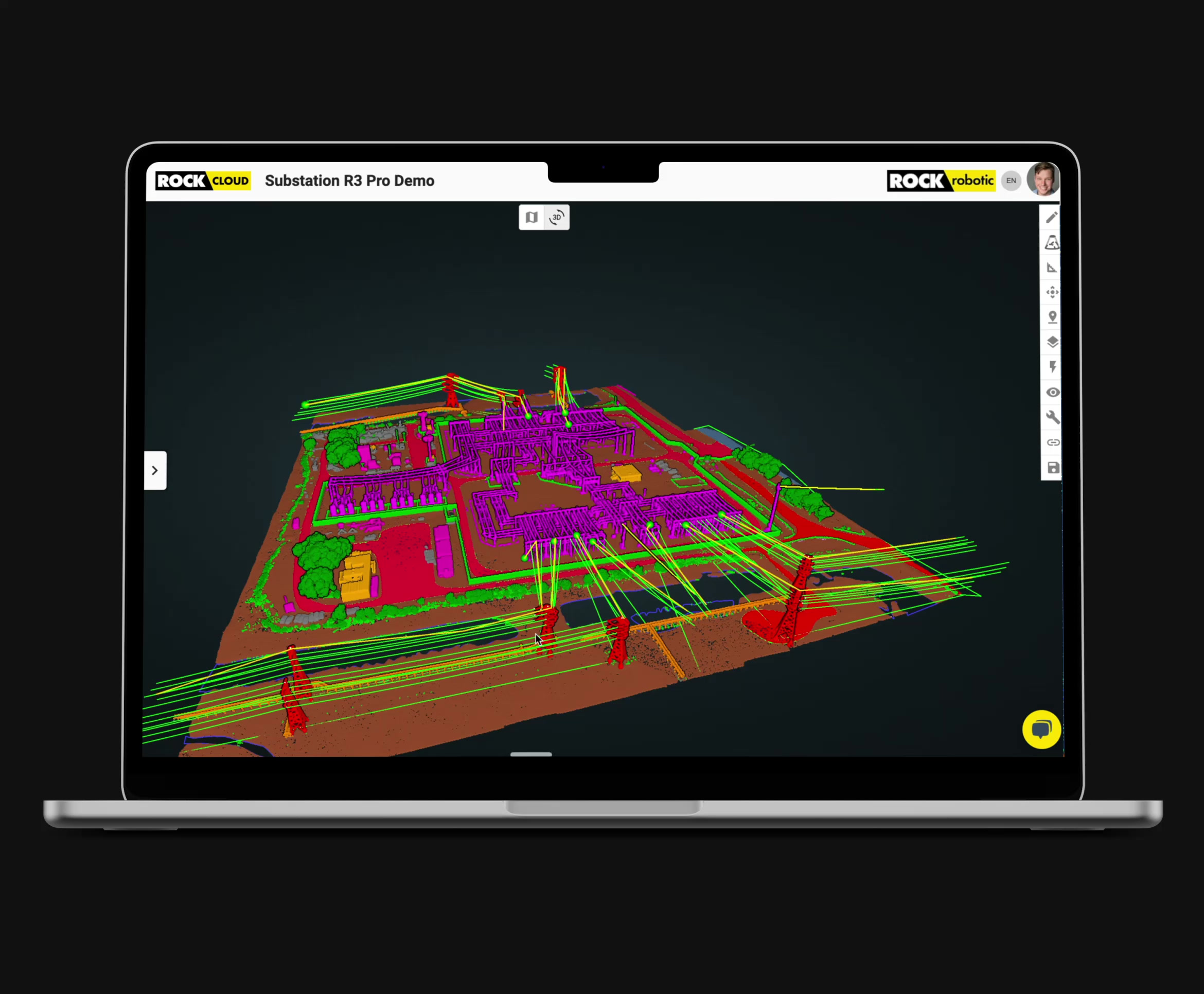
Compare, Align, & Merge Data
Easily compare, align and merge your data with complete control, unlike any processing platform you've seen.
Merge Point Clouds & CAD
Easily import CAD drawings to overlay into your 3D LiDAR data, or view it in 2D.
Manage Projections
Easily re-project your data into the correct datum to match GCPs or different project requirements. Use any standard projection or designate a custom coordinate system.
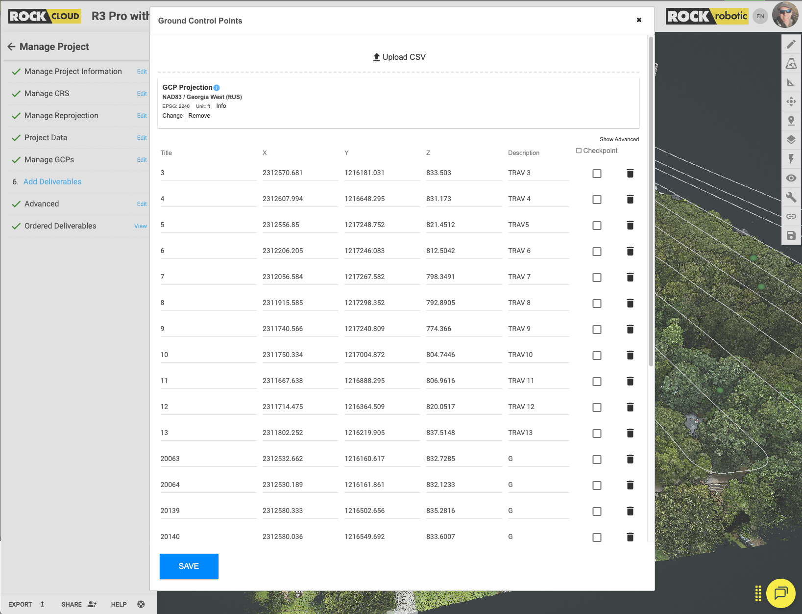
GCPs & Accuracy Reports
Effortlessly upload a CSV of ground control points to your project. Use the Quick Alignment Tool to align your dataset for survey-grade accuracy.
Stockpile Volumetrics
Use the Stock Pile Tool to click and draw a polygon around any object in your point cloud to calculate the volume and cut/fill.
Data Sharing
Easily share projects with your clients from email or share to a wider audience with share links. No additional licenses necessary.
Orthomosaic Support
Upload your orthomosaics to share, measure, and host the 2D data on the ROCK Cloud for a complete deliverable experience.
Visualize and Collaborate, Instantly.
Stop sending massive files. Share your entire project—point cloud, orthomosaics, and photos—with a single, secure web link. Your clients can view, measure, and annotate in a stunning 3D interface from any device, with your company branding front and center. It's the ultimate client deliverable.
Process with Survey-Grade Confidence.
Achieve absolute accuracy with our intuitive georeferencing tools. Upload your GCPs and let our 3D Alignment Tool lock your data into place. Need to change coordinate systems? Our projection manager handles complex transformations with ease, ensuring your data meets any project requirement.
The Ultimate Shortcut: Your AI-Powered CAD Team.
This is where ROCK Cloud changes the game. Order professional deliverables like ROCK Surveyor or ROCK Planimetrics directly from your project. Our advanced AI, combined with expert human QC, automatically extracts ground surfaces, contours, building footprints, curb lines, and more, delivering a CAD-ready file in days, not weeks.
AI-Powered Deliverables On Demand
Transform your point cloud into survey-grade CAD files with our automated extraction services.Powered by AI and verified by human experts.
ROCK Surveyor
Automatic ground classification, bare earth models, contours, and DTM generation
Deliverables Include:
- Classified Point Cloud
- Contour Lines
- Digital Terrain Model
- Accuracy Report
ROCK Planimetrics
AI-powered feature extraction with human QC for survey-grade CAD deliverables
Deliverables Include:
- Building Footprints
- Curb Lines
- Road Markings
- Utility Infrastructure
- Vegetation Boundaries
ROCK Vegetation Management
Specialized analysis for utility corridor vegetation encroachment
Deliverables Include:
- Vegetation Classification
- Encroachment Analysis
- Clearance Reports
- Risk Assessment
Why Leading Firms Choose ROCK Cloud
Scale Without Hiring
Our AI team becomes your drafting department
50% Faster Delivery
From point cloud to CAD in days, not weeks
Impress Clients
Share stunning 3D views with a simple link
No IT Headaches
Cloud processing eliminates hardware limits
The Engine for Modern Surveying & Mapping Firms
ROCK Cloud has fundamentally changed our workflow. What used to take days of manual drafting in Civil 3D is now handled by ROCK Pro Services overnight. We're completing more jobs and our clients are blown away by the interactive deliverables.
As a smaller drone service company, ROCK Cloud lets us compete with the big guys. We can fly a site and deliver a full set of survey-grade planimetrics without needing an in-house CAD team. It's the key to our profitability.
Simple, Transparent Pricing
Start with a free trial. Scale as you grow.
ROCK Cloud Business Plan
Built for Teams and Organizations
Shared storage starting at 2 TB. Start with 5 users and scale. Fine‑grained roles and permissions give you complete control across folders and projects.
Shared Storage
Enterprise storage pools starting at 2 TB with room to grow.
Multi‑User
Start with 5 users. Add seats as your team expands.
Network License
Network‑based processing licenses auto check‑in/out across your team.
ROCK Cloud Enterprise Roles and User Permissions
ROCK Enterprise gives control and flexibility for organizations.
| Permission | Enterprise Manager | Creator | User |
|---|---|---|---|
| Manage Users | ✔ | — | — |
| Manage Enterprise | ✔ | — | — |
| Purchase Tokens | ✔ | ✔ | ✔ |
| Create Folder | ✔ | ✔ | — |
| View All Folders* | ✔ | — | — |
| Modify All Folders* | ✔ | — | — |
| Modify Own Folder (owner or editor) | — | ✔ | ✔ |
| Modify All Projects* | ✔ | — | — |
| Delete All Projects* | ✔ | — | — |
| View All Projects* | ✔ | — | — |
| Modify Own Projects (owner or editor) | — | ✔ | ✔ |
| Delete Own Projects (only owned projects) | — | ✔ | ✔ |
| View Own Projects (owner, editor, or viewer == "own | ✔ | ✔ | ✔ |
| Create Project | ✔ | ✔ | — |
| Order deliverables on projects you own | ✔ | ✔ | ✔ |
| Share Own Folder (owner or editor) | ✔ | ✔ | ✔ |
| Share All Folders* | ✔ | — | — |
| Transfer Ownership | Only Owner | ||
| View All jobs ordered | ✔ | — | — |
| View Own jobs ordered | ✔ | ✔ | ✔ |
| View All Receipts for orders | ✔ | — | — |
| View Own Receipts for orders | ✔ | ✔ | ✔ |
* “All” refers to all projects/folders within the enterprise, not all projects on the platform.
Ready to Streamline Your LiDAR Workflow?
Experience the power, simplicity, and efficiency of the ROCK Cloud for yourself.Start your free trial today and see how easy it is to turn your data into profit.
No credit card required • Full access to all features • Cancel anytime