GCP Best Practices for Aerial Surveying Projects
Jan 18, 2023
Ground Control Points (GCPs) are a crucial part of aerial surveying. They help make sure the data collected is as precise as possible. If you're in the surveying industry, it's important to know the best ways to place GCPs to get the best results from your aerial surveying projects. In this article, we'll go over some important points to consider when placing GCPs and some best practices for getting the most out of them.

Key Considerations
Marking Aerial Targets
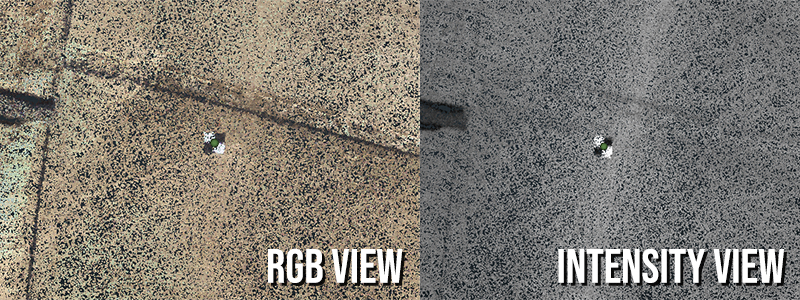
We advise against using reflective tape, also known as retro-reflective materials, for your targets as it can cause a heavy reflection around the target which can negatively impact the accuracy of your results.
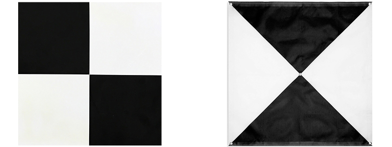
To create an effective aerial target, use a large object with high color contrast (e.g., black and white) that is visible from the air.
Here are a few examples to consider for purchase:
Visibility
One of the main things to keep in mind when placing GCPs is visibility. You want to make sure the points are easy to see and access, so use durable markers or flags to mark them. This way, it's easy to find and identify the points when collecting data from the air.
Location
It's also important to consider the location of the GCPs relative to the area being surveyed. You want to place them in a way that allows for accurate and precise measurement of the collected data points. For example, if you're collecting data from a large area, consider placing GCPs at regular intervals to ensure the whole area is accurately mapped.
Placement Accuracy
Accuracy of location and elevation is another important factor to consider when placing GCPs. You need to ensure you accurately record each GCP's location and elevation as this information is used to calculate the coordinates of the data points being collected. To ensure accuracy, you might need to use precise surveying equipment like GPS or total stations to measure the location and elevation of the GCPs.
*Related: Use ROCK Cloud's Auto Align GCP tool to dial in your GCPs quickly. *
GCP Best Practices
Here are some best practices you can follow when placing GCPs to get the best results from your aerial surveying projects:
Use a sufficient number of GCPs.
The number you need will depend on the size and complexity of the area being surveyed, as well as the accuracy requirements of the project. As a general rule, it's best to use as many GCPs as possible to ensure the data collected is accurate and precise.
Distribute GCPs evenly.
It's important to distribute GCPs evenly throughout the surveyed area to ensure all areas are accurately mapped.
Placing Your Targets
To ensure accurate results, place aerial targets in a flat, open area where they can remain stable and be easily seen by the sky. Avoid placing targets on small features like fire hydrants or water meters, as they can cause inaccuracies in your DEM and accuracy report. Additionally, it is not recommended to place targets on the back of curbs or in tall grass, as these areas can cause the targets to wobble or shift during flight.
*Related: How to add GCPs to your point cloud in ROCK Cloud *
Flying Your Targets
For optimal point cloud alignment with your GCPs, it is recommended to make a manual flight pass over your GCPs at a lower altitude. This can be done at a recommended height of 30 meters (100 ft) and a speed of 2 m/s (4.5 mph) for the highest point density. To achieve the best results, it is recommended to do this before or after a battery swap, and to use a target that is close to your landing zone.
A successful aerial mapping project begins with well-placed, highly visible GCPs. We hope you can get your next job off to a great start by keeping these tips in mind.
Visit rockrobotic.com to learn more about our survey-grade hardware and processing software.