Ultra Field-to-Finish Bundle
Fly Higher. Map Faster. Capture True Ground.
What You’ll Get
- ROCK Desktop PPK Processing (Year 1)
- ROCK True‑position Photogrammetry (Year 1)
Limited‑time Bonuses
See details- Ultra Quick‑Start Implementation
- ROCK Cloud Business (Year 1)
- ROCK Academy — 6 Seats
- Pro Services Credit — $1,500
- ROCK Network RTK Subscription (Year 1)
- ROCK RTK Network On‑Ramp
M6C3YW at purchase to receive bonuses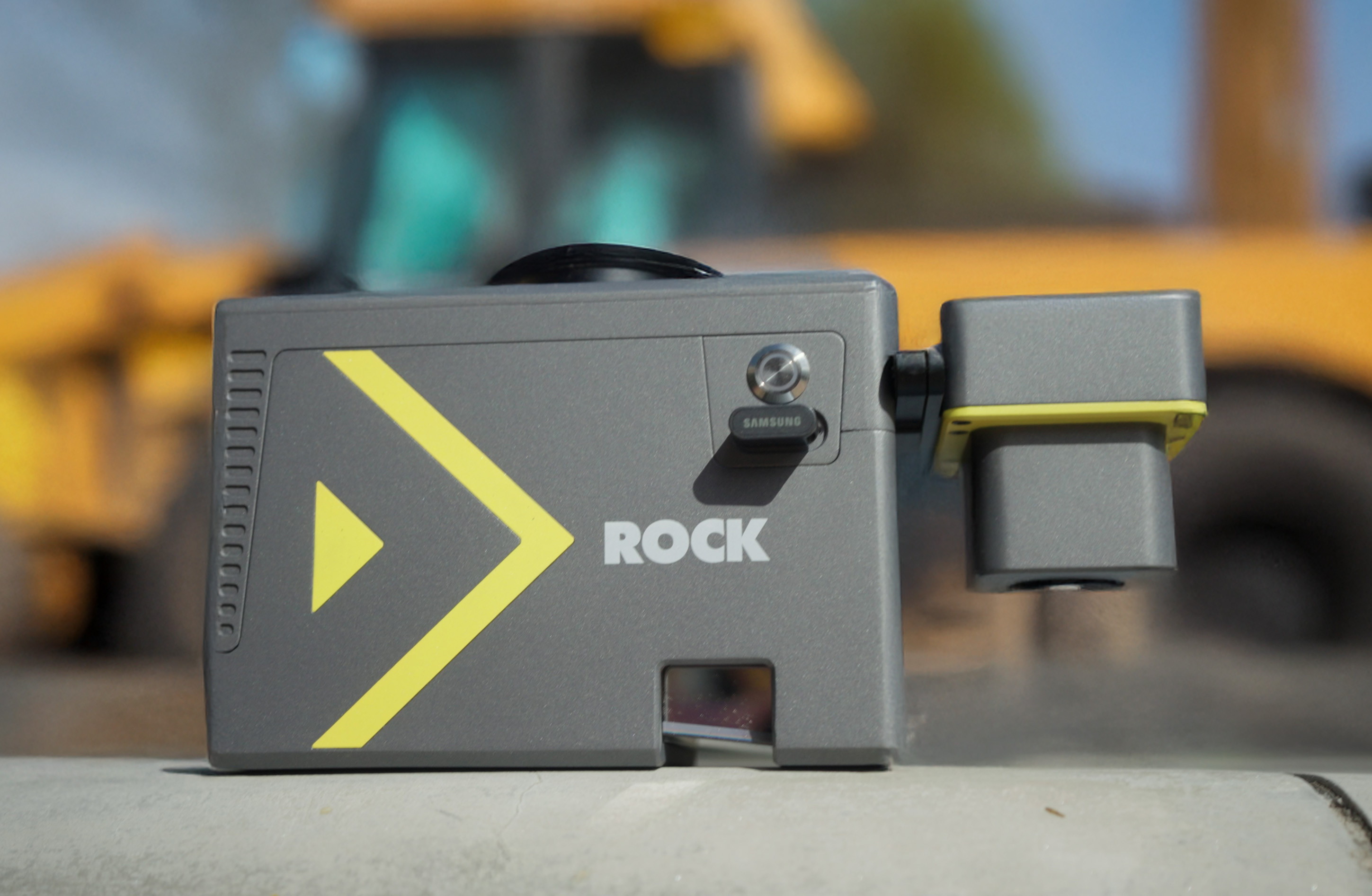
Learn More
See What Others Have Said
Discover real-world results from teams using the ROCK Ultra.
ROCK Ultra LiDAR: 188 Acres Surveyed in 17 Minutes – A Game Changer for D.C. Johnson & Associates
Discover how D.C. Johnson & Associates leveraged the ROCK Ultra LiDAR drone system to survey 188 acres in just 17 minutes, replacing days of manual work and delivering unparalleled accuracy in challenging Florida environments.
Fly Higher, Finish Faster: How Florida Design Consultants Mapped 500+ Acres in One Flight with ROCK Ultra
Discover how Florida Design Consultants, Inc. used the ROCK Ultra to survey a complex 500+ acre residential site in a single 70-minute flight, saving days of fieldwork and revolutionizing their workflow.
30 Minutes On-Site: A ROCK Ultra Drone LiDAR Case Study with Dylan Gorman
Aerial Intelligence Expert Dylan Gorman from PilotByte.com demonstrates how the ROCK Ultra LiDAR system captured a complex 133-acre highway intersection in just 30 minutes on-site.
Above the Wires: How the ROCK Ultra’s High-Altitude LiDAR Makes Hazardous Surveys Safe
This case study explores a 178-acre canyon survey where high-voltage power lines posed a critical threat. See how the ROCK Ultra's ability to fly at 120m AGL turned a high-risk mission into a safe and efficient operation.
Drone LiDAR Case Study: Flawless Urban Breaklines in Denver with the ROCK Ultra
In a high-efficiency urban mapping mission over Denver, the ROCK Ultra LiDAR system captured 160 acres of complex terrain in a single battery-powered flight. Flying at 120 meters and 10 m/s, the ROCK Ultra delivered crisp, colorized point clouds with ≤3 cm vertical accuracy—proving its power, speed, and precision in dense urban environments.
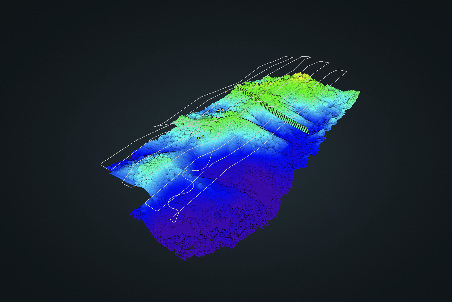
ROCK Ultra Project: Van Bibber Creek — High-Detail LiDAR Mapping at 120m Altitude
The ROCK Ultra LiDAR mapped Van Bibber Creek at 120m altitude, capturing detailed terrain through dense vegetation. Its seven-return capability ensured high-precision data, proving ideal for large-area surveys, environmental assessments, and efficient drone operations.
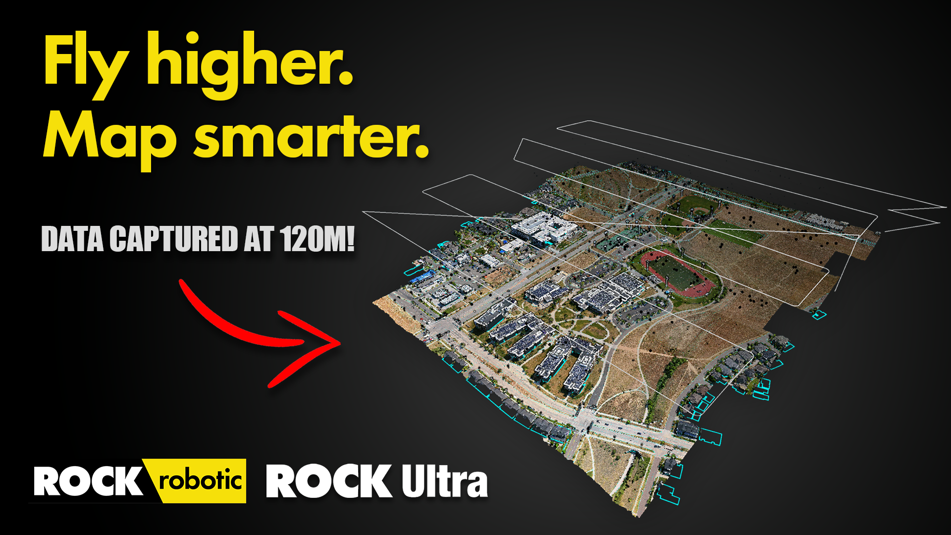
Introducing ROCK Ultra: Survey-Grade Aerial LiDAR from 120m with No Compromises — See the Data
Discover how the ROCK Ultra LiDAR system captures high-resolution, survey-grade data from 150 meters AGL. This in-depth walkthrough explores point cloud quality, vegetation penetration, and large-area mapping capabilities—making high-altitude UAV LiDAR practical for real-world surveying workflows.
High-Altitude LiDAR: Mapping at 150m AGL with the ROCK Ultra (Data Walkthrough)
Discover how the ROCK Ultra LiDAR system captures high-resolution, survey-grade data from 150 meters AGL. This in-depth walkthrough explores point cloud quality, vegetation penetration, and large-area mapping capabilities—making high-altitude UAV LiDAR practical for real-world surveying workflows.

Dear Business Owner,
When I started ROCK Robotic, I wasn’t trying to build the fanciest LiDAR system in the world. I wanted to solve a simple but painful problem: LiDAR was too complicated, too expensive, and too hard to use.
I believed surveyors and mapping professionals deserved better. You shouldn’t need a PhD or a million-dollar budget to collect accurate 3D data. You should be able to fly your drone, hit the “easy button,” and walk away with results you can trust.
That’s why we created the ROCK Ultra. It’s designed to take you from beginner to expert overnight. Fly at max altitude with confidence. Capture the true ground under the thickest canopy. Cover 2–3x more area in a single flight. Then upload to ROCK Cloud and, with just a few clicks, turn that data into professional deliverables.
It’s the exact tool I wish I had when I first stepped into this industry. And it’s backed by the same principle we built ROCK Robotic on: make LiDAR simple, powerful, and profitable.
Here’s my promise: if you put the Ultra into your workflow, it will save you time, reduce your headaches, and pay for itself faster than you think. That’s why we back it with our “First Flight to Finished” Guarantee.
This isn’t just hardware. It’s a complete ecosystem to help you win more bids, deliver faster, and grow your business. And my team and I will be with you every step of the way.
See you in the skies,
Harrison Knoll
Founder, ROCK Robotic
P.S. Every month you wait to adopt the Ultra, you’re leaving projects, profits, and time on the table. Book your demo today.
Experience the ROCK Ultra in 3D
Explore every detail of our flagship long-range LiDAR system
360° View
Rotate to explore
Full Detail
Zoom for close-ups
Interactive
Click and drag
Results from those we've helped.
Real comments from real teams using the ROCK workflow.
“A huge savings in time, manpower, the control that’s needed to set everything up… just all around, it’s a huge benefit in time.”
“The fact that we're showing this big of an improvement is a testament to the other guys who aren't doing much [LiDAR capturing]. They should probably get on board.”
“The team at ROCK is by far the best in the industry. We've worked with a number of other companies and these guys are hands down the best.”
“ROCK Robotic has seriously helped our survey business get to a new level of service and productivity. Highly recommend ROCK Pro Services and their LiDAR equipment.”
“The thing that I'm most pleased about is the ease of use of the LiDAR. We were able to take the hardware and deliver a product – the first time. The client is absolutely over the moon with the data we delivered.”
“The Ultra cut our field time on a 500-acre project from three days to four hours. The bare-earth data was the cleanest we've ever seen.”
ROCK Robotic does not guarantee any specific results. Experiences discussed may not be typical. Background, education, application, and effort may affect your business experience. Your results may vary.
30‑Day “First Flight to Finished” Guarantee
Ultra Field‑to‑Finish Bonuses
For a limited time, get the most out of your Ultra with these additional benefits!
M6C3YW at purchase to receive bonusesROCK Robotic — Trusted by Hundreds
Teams of every size trust ROCK to deliver survey‑grade results
... and Hundreds more
What You'll Need
Drone (choose one)
Base Station
- EMLID Reach RS3 for a high‑quality PPK solution (Learn More)
* Other base stations that track all constellations and produce a 1 second RINEX file and mixed ephemeris file may work. We recommend the EMLID because we KNOW it works and we can support it.
What You’ll Get
Your End-to-End LiDAR Solution: From data capture in the field to final deliverables, we provide the tools and expertise to streamline your entire workflow.
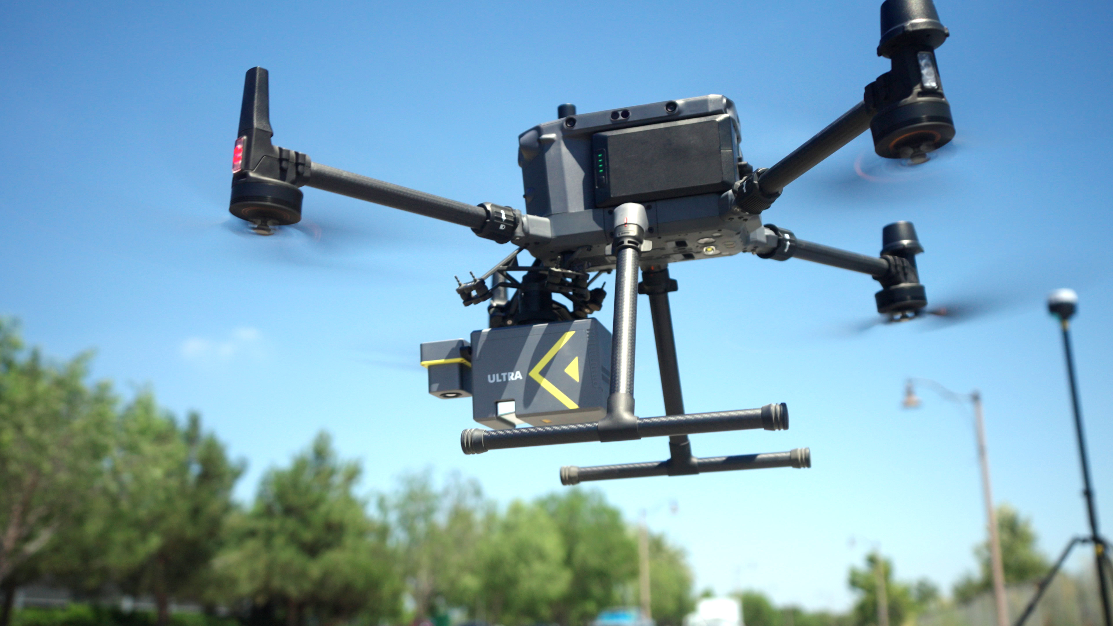
ROCK Ultra
Survey-grade ROCK Ultra, engineered for accuracy and efficiency in any environment.
Learn More →Cloud Software
The ROCK Cloud platform for seamless data processing, analysis, visualization, and deliverable generation.
Learn More →Professional Services
Your outsourced CAD team. Get survey-grade topographic maps, planimetrics, and PLS-CADD deliverables from our experts.
Learn More →About Our Founders
Rock Robotic was built by brothers Harrison and Alex Knoll with one mission: make LiDAR simple, accurate, and accessible.

Harrison Knoll — CEO
Harrison (CEO) saw firsthand the frustration surveyors faced with expensive, complicated tools. He knew there had to be a better way — faster, easier, and built for the people actually doing the work.
Alex Knoll — CTO
Alex (CTO) had the technical firepower to make it happen. With deep expertise in LiDAR systems, drones, and software, he engineered the ROCK Ecosystem — hardware and software that just works in the field.
Together, they took LiDAR workflows that used to take weeks… and turned them into hours. What started as a bold idea is now trusted by hundreds of companies in surveying, construction, forestry, mining, and utilities.
Their belief is simple: technology should serve people, not slow them down. And that’s the spirit driving Rock Robotic forward today.
Imagine the smile on your customer's face
when you show them...
Learn More
View the Datasets
Browse real ROCK Ultra sample datasets to evaluate results in your browser.
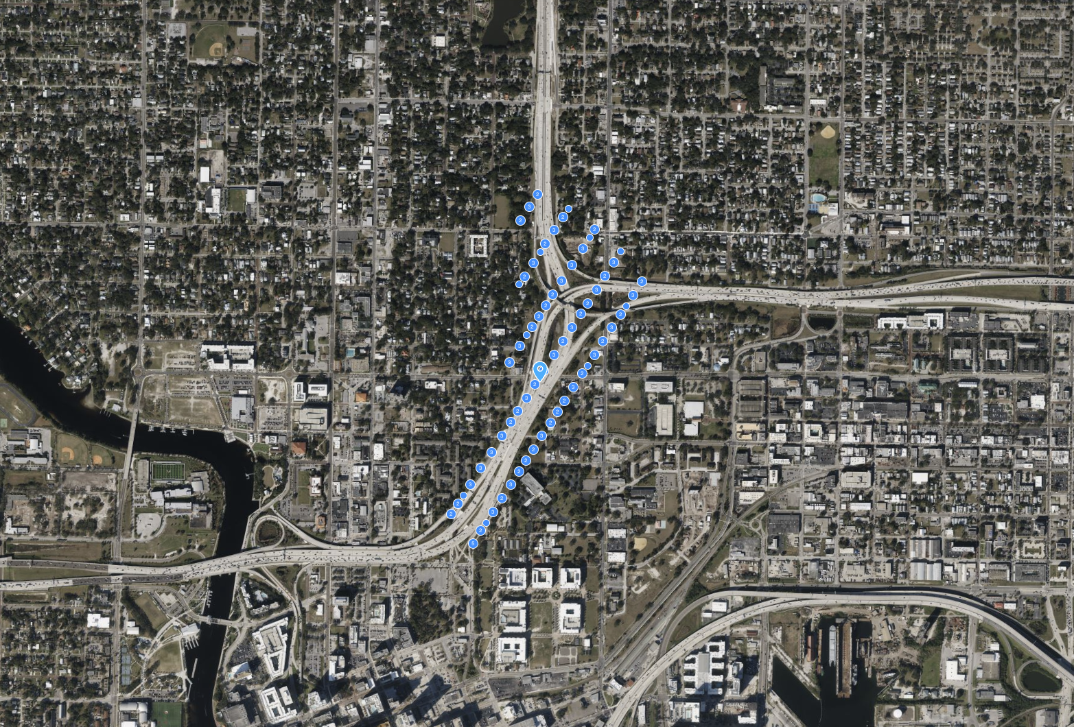
ROCK Ultra – Intersection Flyover
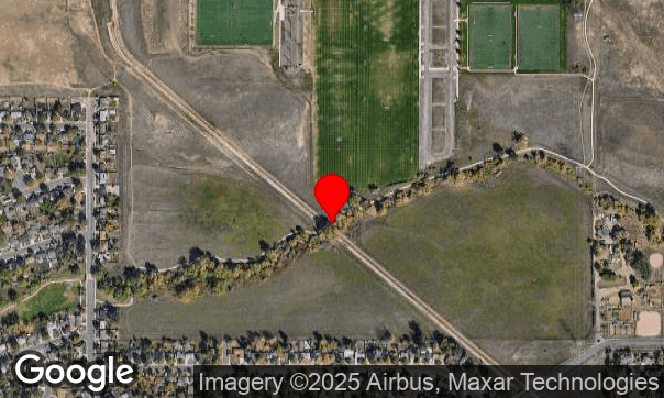
Experience the ROCK Ultra mapping a 133-acre highway interchange from 115 m at 7.5 m/s, capturing every detail of the busy I-275 & I-4 merge in Tampa Bay.
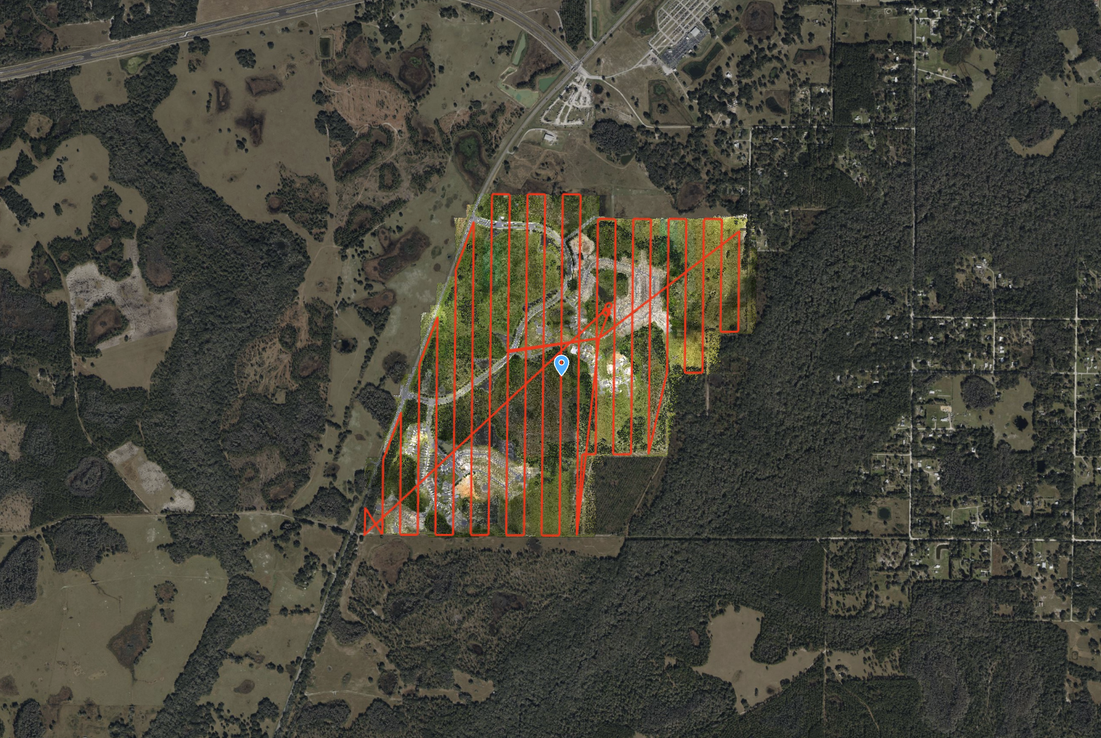
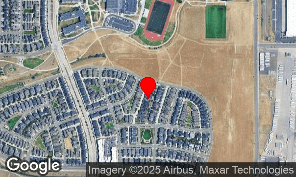
ROCK Ultra – Zephyrhills Residential Development
Flying at 120 m and 8 m/s, the ROCK Ultra mapped a massive 546-acre multi-phase development in Zephyrhills, FL, capturing wetlands, dense vegetation, and construction zones with precision.
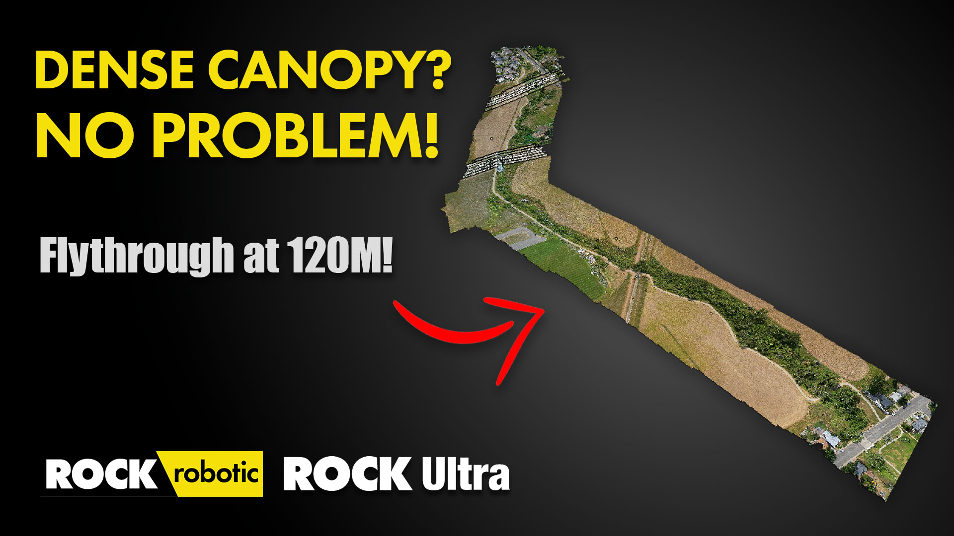
ROCK Ultra – Van Bibber Creek (120m, 5 m/s)
Testing the ROCK Ultra’s canopy penetration and ground detail capture at Van Bibber Creek.
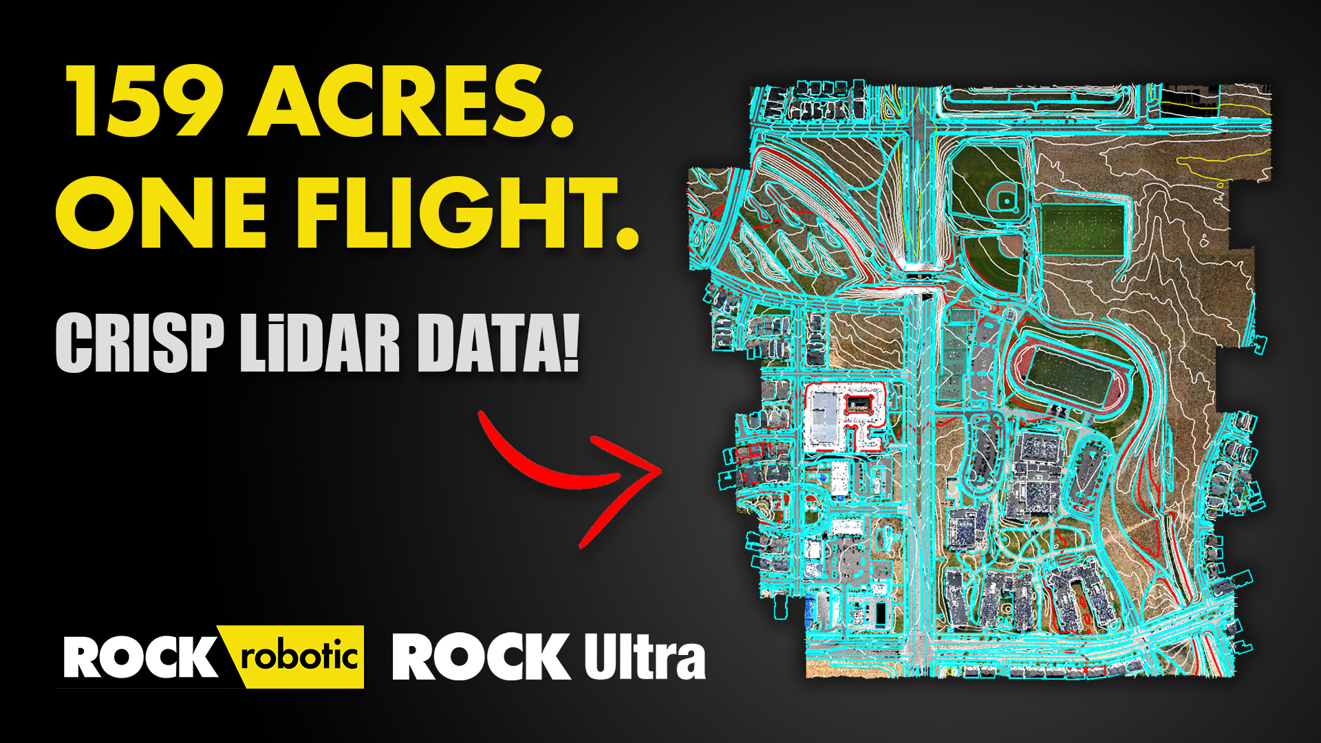
ROCK Ultra – Big Denver Aerial Survey
Watch the ROCK Ultra soar—mapping 159 acres from 120 m at 10 m/s with accuracy and speed.
Book a Live Demo / Get Pricing
Tell us about your drone and workflows. A specialist will tailor the demo to your projects. Be sure to mention the Ultra Field‑to‑Finish Bonuses.
M6C3YW at purchase to receive bonusesSales: +1 (720) 706‑8648 · sales@rockrobotic.com
Frequently Asked Questions
Yes—DJI Skyport mount supported.
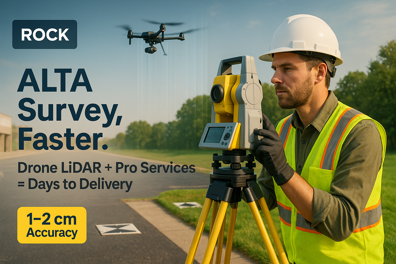
With proper workflow and PPK, Ultra achieves survey‑grade outputs suitable for topo/ALTA; request a spec walk‑through and sample datasets.
Capture → quick QC in ROCK Desktop → upload to ROCK Cloud → order deliverables in a click. Many teams go field‑to‑finish in hours instead of weeks.
Yes—via partner financing (subject to approval).
Learn More
Latest Insights & Guides
Explore our latest articles on LiDAR mapping, surveying best practices, and industry insights

Aug 29, 2025
The Advantages of Drone Surveying vs. Traditional Methods
A detailed breakdown of how modern drone LiDAR workflows generate massive ROI by drastically cutting field time, reducing operational costs, and improving data quality compared to traditional methods.
Aug 27, 2025
ROCK Ultra LiDAR: 188 Acres Surveyed in 17 Minutes – A Game Changer for D.C. Johnson & Associates
Discover how D.C. Johnson & Associates leveraged the ROCK Ultra LiDAR drone system to survey 188 acres in just 17 minutes, replacing days of manual work and delivering unparalleled accuracy in challenging Florida environments.
Aug 20, 2025
The Complete ALTA Survey Playbook: Traditional vs. ROCK Ultra + Pro Services
Comprehensive guide comparing traditional ALTA/NSPS survey methods with ROCK Ultra drone LiDAR workflows. See real cost breakdowns showing 32-48% savings, detailed workflow comparisons, and proven strategies for faster survey delivery.
Aug 20, 2025
Fly Higher, Finish Faster: How Florida Design Consultants Mapped 500+ Acres in One Flight with ROCK Ultra
Discover how Florida Design Consultants, Inc. used the ROCK Ultra to survey a complex 500+ acre residential site in a single 70-minute flight, saving days of fieldwork and revolutionizing their workflow.

Aug 20, 2025
ROCK Robotic at Commercial UAV EXPO: See the All-New ROCK Ultra!
Join ROCK Robotic at the Commercial UAV EXPO in Las Vegas to see the groundbreaking ROCK Ultra in person and receive exclusive offers!
Aug 18, 2025
30 Minutes On-Site: A ROCK Ultra Drone LiDAR Case Study with Dylan Gorman
Aerial Intelligence Expert Dylan Gorman from PilotByte.com demonstrates how the ROCK Ultra LiDAR system captured a complex 133-acre highway intersection in just 30 minutes on-site.
Aug 18, 2025
ROCK Ultra – Intersection Flyover
Experience the ROCK Ultra mapping a 133-acre highway interchange from 115 m at 7.5 m/s, capturing every detail of the busy I-275 & I-4 merge in Tampa Bay.
Aug 10, 2025
ROCK Robotic Unveils ROCK Ultra LiDAR, Enabling Surveyors to Map 2-3x More Area Per Flight
The new ROCK Ultra LiDAR system revolutionizes large-scale aerial surveying with a powerful long-range sensor and an "Easy Button" workflow, allowing professionals to fly higher and faster without sacrificing data quality.
Ready to Transform Your Workflow?
Join professionals who have revolutionized their mapping operations with the ROCK Ultra.