ROCK Ultra Project: Van Bibber Creek — High-Detail LiDAR Mapping at 120m Altitude
Jul 31, 2025
At ROCK Robotic, we are always pushing the boundaries of what's possible with LiDAR technology. Lately, we’ve been enjoying putting the ROCK Ultra through its paces to ensure it meets and exceeds the high standards our customers expect in real-world conditions.
Our latest project at Van Bibber Creek demonstrates the impressive capabilities of the ROCK Ultra LiDAR system flown at 120 meters altitude and 5 meters per second to capture intricate details through dense riparian vegetation with remarkable precision.
Flight Overview and Objectives
Using the ROCK Ultra mounted on a DJI M300 drone, we conducted a detailed survey over Van Bibber Creek. The primary goal was to test the seven-return capability of the ROCK Ultra — a game-changing feature allowing for superior vegetation penetration and detailed ground modeling beneath tree canopies.
Flying at 120 meters altitude not only allowed us to cover the large area efficiently, but also helped us easily maintain an extended line of sight — crucial for safe and effective drone operations, especially in challenging terrains.
ROCK Ultra's Van Bibber Creek Project visualized in the ROCK Cloud
What Our Team Observed
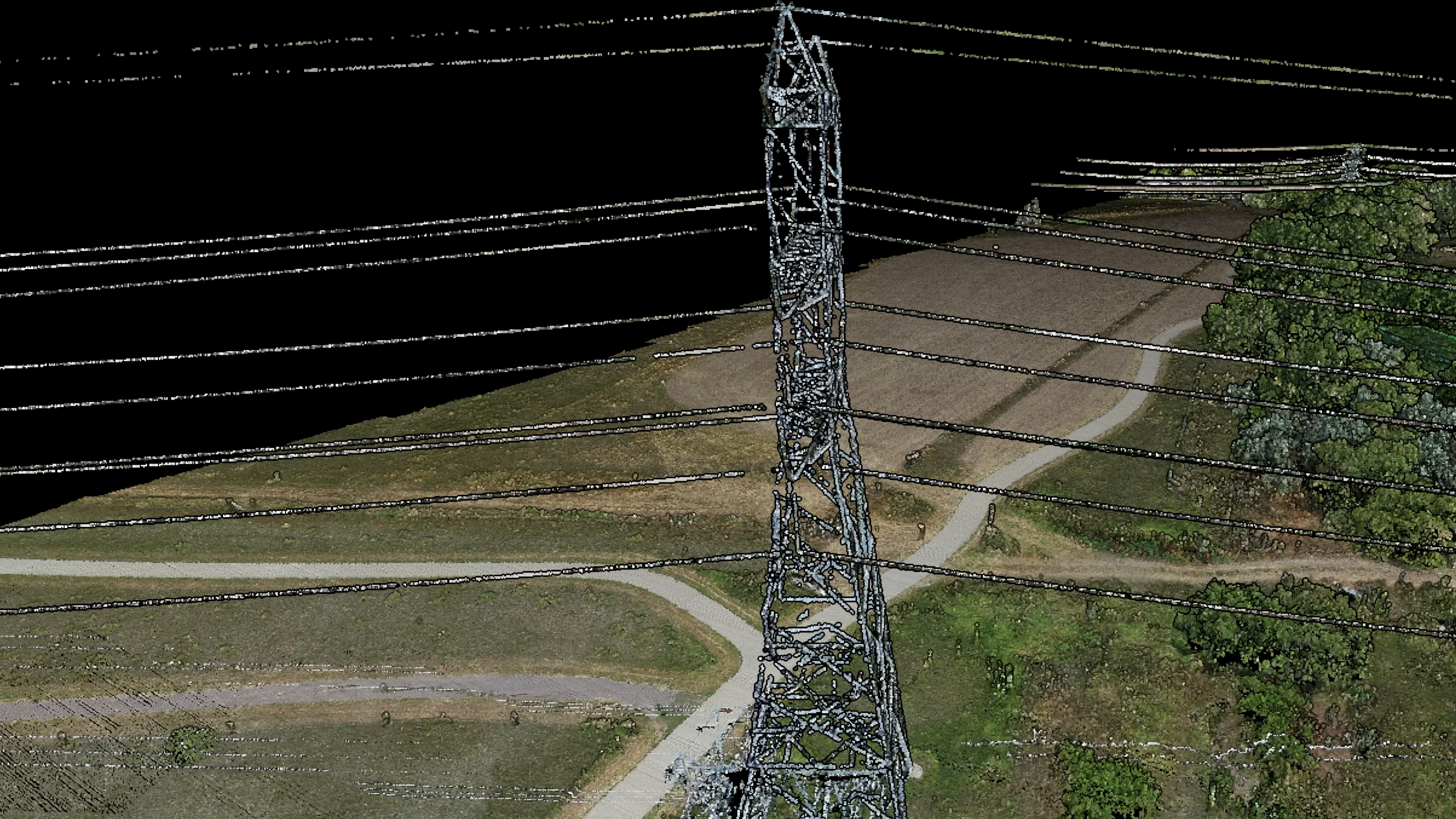
Jamie Lackner, ROCK Pro Services Manager, was the first to walk through the data and was particularly impressed with how well the power lines were captured at the flight altitude, even though that wasn’t a primary objective of this capture.
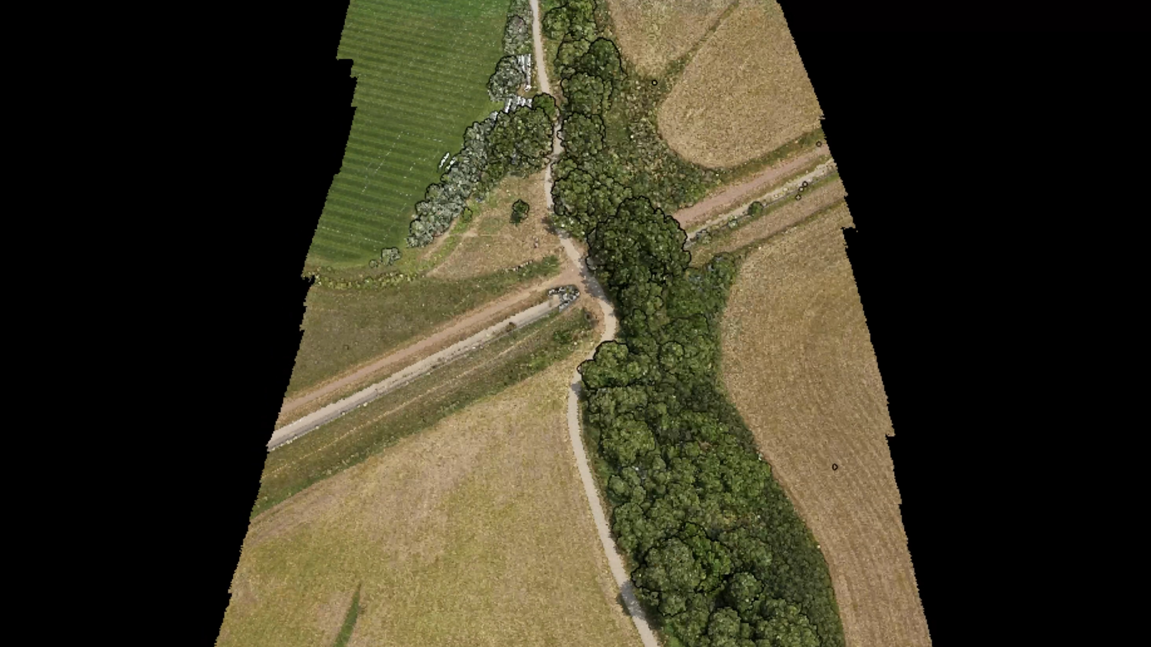
The seven returns enabled detailed visualization of both the vegetation and the ground beneath, highlighting the creek bed's shape and adjacent terrain perfectly for obtaining a DEM and contours of the area.
Key Takeaways
This project highlights how the ROCK Ultra empowers professionals to fly large areas at higher altitudes without sacrificing data quality. It demonstrates the ROCK Ultra’s versatility for crisp data capture that can be used confidently for floodplain studies, environmental assessments, restoration planning, etc. The ROCK Ultra’s seven-returns delivered reliable, high-fidelity results that you can hang your hat on even in challenging vegetated landscapes.
Ready to Elevate Your Surveying Workflow?
Whether it’s utility corridor mapping, dense vegetation penetration, or large-scale topographic projects, the ROCK Ultra is designed to push your capabilities forward.
ROCK Robotic is committed to real solutions for real problems. With ROCK Ultra, the future of drone LiDAR surveying is clearer, safer, and faster than ever before.
Contact the ROCK Team to learn how ROCK Ultra can transform your next project!
Sales: +1 (720) 706-8648 | Email: hello@rockrobotic.com | Visit rockrobotic.com/ultra