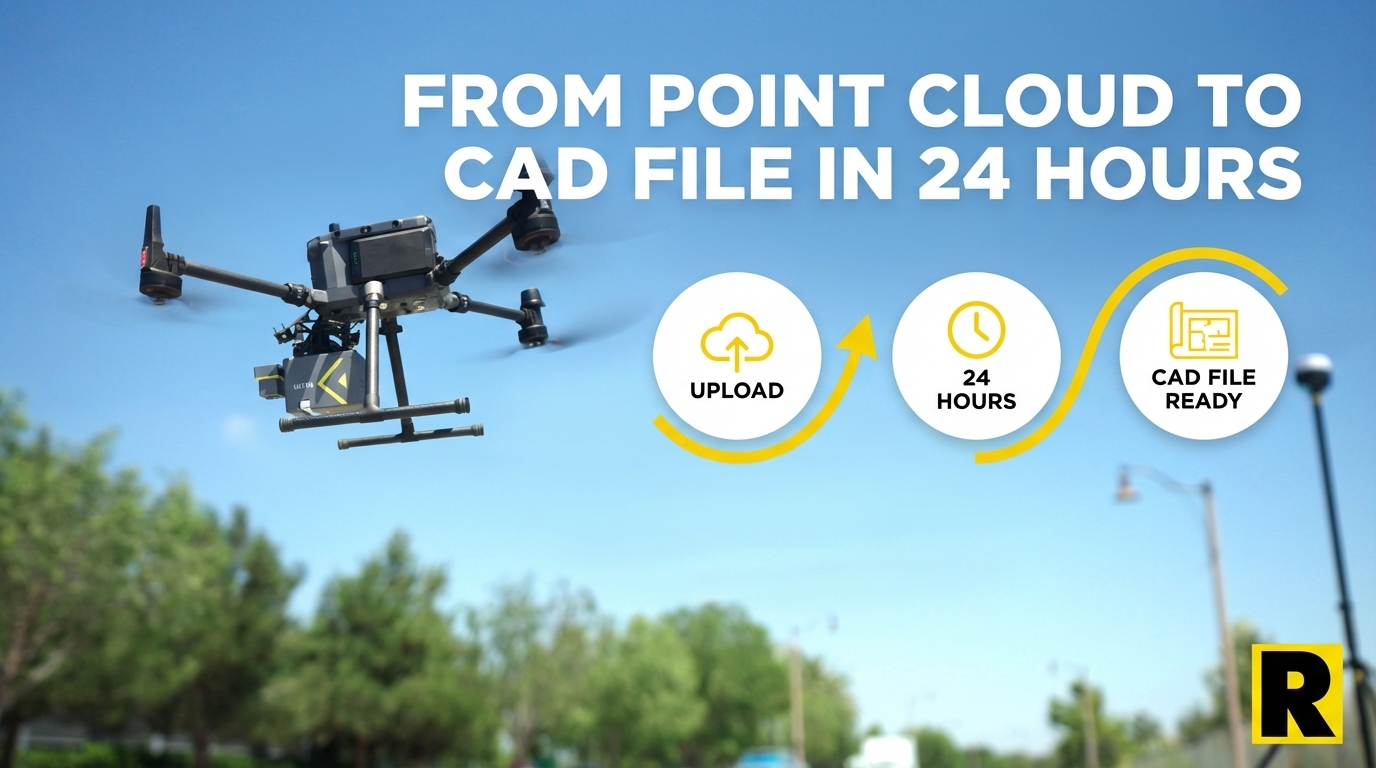
From Point Cloud to CAD File in 24 Hours: How ROCK Pro Services Works
Apr 01, 2026
When survey professionals hear "AI processing," they often picture an algorithm that runs 70% of the way and then stops. You get a point cloud with a decent ground classification and a long afternoon of manual cleanup ahead of you.
ROCK Pro Services is something different. It's a hybrid production pipeline — AI handles the computationally heavy work, then US-based CAD professionals and licensed surveyors handle the work that requires human judgment. The result is a finished deliverable: clean, QC'd, in your CAD layer template, ready for your client.
Here is exactly how it works.
Step 1: Upload to ROCK Cloud
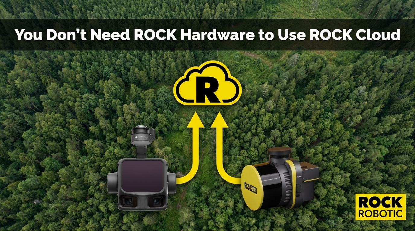
Your field workflow ends when the drone lands. Back in the office — or directly from the field on a tablet — you upload your raw LiDAR data to ROCK Cloud.
ROCK Cloud accepts:
- LAS/LAZ point cloud files from any sensor (ROCK, DJI, GeoCue, YellowScan, Phoenix, GreenValley)
- Orthomosaic imagery for colorized deliverables
- Mission logs and trajectory data
Upload time depends on your internet connection and dataset size. Most 50-150 acre projects upload in under an hour. You can also start a Pro Services order while the upload is still running.
Step 2: Order Your Deliverables
From the ROCK Cloud project dashboard, select the Pro Services deliverable you need:
ROCK Surveyor
Bare earth classification, DTM, and survey-grade contours. Includes:
- Full ground classification with human QC
- Noise filtering and outlier removal
- Hand-drafted breaklines along critical terrain features
- Contour generation at your specified interval
- Deliverable formats: DXF, DWG, DEM, or as specified
Best for: Topographic surveys, grading plans, drainage analysis, ALTA surveys
Turnaround: ~24 hours for standard projects
ROCK Planimetrics
Everything in ROCK Surveyor, plus full feature extraction. Includes 50+ planimetric feature types:
- Building footprints
- Curb lines and edge of pavement
- Parking stall markings
- Fences, walls, and retaining structures
- Utility poles, fire hydrants, manholes
- Trees and significant vegetation
- Signage and site furniture
- Delivered in your firm's custom CAD layer template
Best for: Civil engineering design, ALTA surveys, facility mapping, redevelopment projects
Turnaround: 24-72 hours depending on site complexity and feature density
ROCK Vegetation Management
Utility corridor-specific deliverables for power line inspection and vegetation clearance:
- Wire sag and height calculations
- Vegetation encroachment mapping
- Right-of-way clearance analysis
- Conductor positions verified against point cloud
Best for: Utility companies, T&D contractors, vegetation management firms
ROCK PLS-CADD
Full PLS-CADD-ready deliverable for power line design and analysis. Custom pricing based on corridor length and complexity.
Best for: Power line engineering and structural analysis firms
Step 3: AI Processing Begins
Once your order is placed, ROCK's AI pipeline processes the data:
Automated ground classification — ROCK's classification algorithms, trained on over 50,000 survey projects, run initial separation of ground from vegetation, buildings, vehicles, and noise. This is not a generic algorithm — it's one that has been continuously refined on real survey data from flat Florida subdivisions to dense Hawaiian jungle canopy to Colorado avalanche paths.
Initial feature detection — For Planimetrics orders, AI identifies and pre-classifies building footprints, curb lines, and other high-confidence features from the colorized point cloud and orthomosaic.
Strip alignment verification — The system checks your data quality metrics and flags any strips that need attention before the human team begins work.
The AI layer handles approximately 70-80% of the production work. This is where speed comes from. The next step is where accuracy comes from.
Step 4: Human QC and Production
ROCK's US-based team of CAD drafters, GIS analysts, and licensed surveyors takes over where the AI leaves off.
Classification boundary review — A human analyst reviews every significant ground/non-ground boundary in the classified point cloud. Bridge decks, retaining walls, dense brush, and building edges all get manual attention. Classification errors at these boundaries are where DTM artifacts and bad contours originate — and they get caught here, not by your client.
Breakline drafting — Survey-grade breaklines are hand-drafted along critical terrain features: curb tops and bottoms, ridge lines, drainage channels, retaining wall faces. This is work that no algorithm currently does at survey-grade accuracy. Our team does it on every ROCK Surveyor and Planimetrics order.
Planimetric feature completion — For Planimetrics orders, the AI-detected features are verified, and any missed features are digitized manually. The team works from both the point cloud and the orthomosaic simultaneously, cross-referencing to ensure nothing is missed and nothing is mislocated.
Custom CAD layering — Deliverables are organized into your firm's layer scheme. If you provide a template, your deliverable arrives in exactly your layer structure. No reformatting before you hand it to your engineer or client.
Final QA review — A licensed surveyor reviews the completed deliverable before it ships. Accuracy is guaranteed — if you find an issue, ROCK revises it at no additional cost.
Step 5: Delivery and Review
Completed deliverables are delivered directly to your ROCK Cloud project. You download them in your specified format (DXF, DWG, GeoTIFF, etc.) and review using ROCK Cloud's browser-based point cloud viewer — where you can visually verify the deliverable against the original point cloud.
If you want to share the project with your client, a single link gives them a branded web viewer where they can explore the 3D data, take measurements, and review the deliverable — without installing anything.
Real Project Examples
159-acre urban Denver site — Data uploaded Monday morning. ROCK Surveyor breaklines and DTM delivered in under 48 hours. The project required engineering-grade breaklines across a dense urban streetscape. Output was described as "the cleanest we've ever seen" from a client with 15+ years in the industry.
500+ acre Florida residential development — Single 70-minute flight with the ROCK Ultra. Survey-grade topo and planimetrics ordered through Pro Services. Brian Drinkwater, Survey Project Manager at Florida Design Consultants: "We would have been out there two or three days, just cycling batteries, trying to keep up to get this entire site done. We did this one in an hour and ten minutes of air time."
133-acre highway interchange (I-275/I-4) — Dylan Gorman of PilotByte captured the full interchange in a 30-minute site visit. Pro Services delivered the complete planimetric and topo package for the complex multi-level structure.
What You Are Actually Paying For
When you order ROCK Pro Services, you're not buying software. You're buying the accumulated expertise of a team that has processed over 50,000 survey projects — every terrain type, every edge case, every classification challenge.
A single firm's in-house team, no matter how skilled, sees a fraction of that project variety. ROCK's team has solved the specific problems your site will throw at them — many times before. That's the quality difference that shows up in the deliverable.
Your field expertise captures the data. ROCK's production expertise turns it into revenue.
See ROCK Pro Services in action: Denver Urban Breaklines Case Study