Mapping an Open-Pit Copper Mine in British Columbia with the ROCK Ultra Drone LiDAR System
Nov 13, 2025
High-Altitude Mapping, Zero Rim Risk
At one of the largest open-pit copper mines in British Columbia, Keith Seidler (Chief Geologist) and Jeffrey Wannop (Senior Geologist & UAV Pilot) faced a familiar challenge: safely mapping a massive pit without flying dangerously close to its steep walls and power infrastructure.
Traditional workflows required six to eight flights spread across three days—a slow, risk-prone process that left plenty of room for error.
With the ROCK Ultra LiDAR, they captured the same dataset in just three flights over a single day, maintaining a safe standoff altitude of 400 feet (120 meters) AGL while still achieving survey-grade precision.
Typically it would have taken us six or eight flights spread out over three days. Instead, we captured it in three flights in a single day.
— Keith Seidler, Chief Geologist
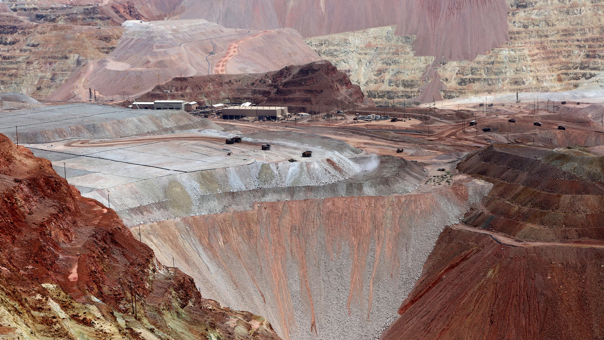
The Site: A 600-Meter-Deep Copper Mine in British Columbia
Set against the rugged terrain of central British Columbia, the team’s mission site presented a 600-meter elevation difference from pit rim to floor.
Operating drones at such depths introduces serious risk—from rim strikes and steep benches to overhead power lines and haul-road obstructions.
The ROCK Ultra LiDAR allowed the crew to fly well above those hazards, maintaining visual contact and complete coverage from top to bottom of the mine.
Our goal was to be able to fly around the rim of the pit and still capture high-quality data from top to bottom.
— Keith Seidler
Why ROCK Ultra Was the Right Tool for the Job
The ROCK Ultra LiDAR is purpose-built for long-range, high-altitude aerial mapping—ideal for large, complex environments like open-pit mines.
Powered by advanced ROCK LiDAR technology, it captures high-density point clouds at extended ranges with sub-5 cm accuracy. Its multi-return system ensures detailed data capture even over challenging terrain and vegetation.
When integrated with Rock Cloud, users can process, analyze, and visualize datasets seamlessly—from raw point clouds to deliverables such as contours, DTMs, and volume reports.
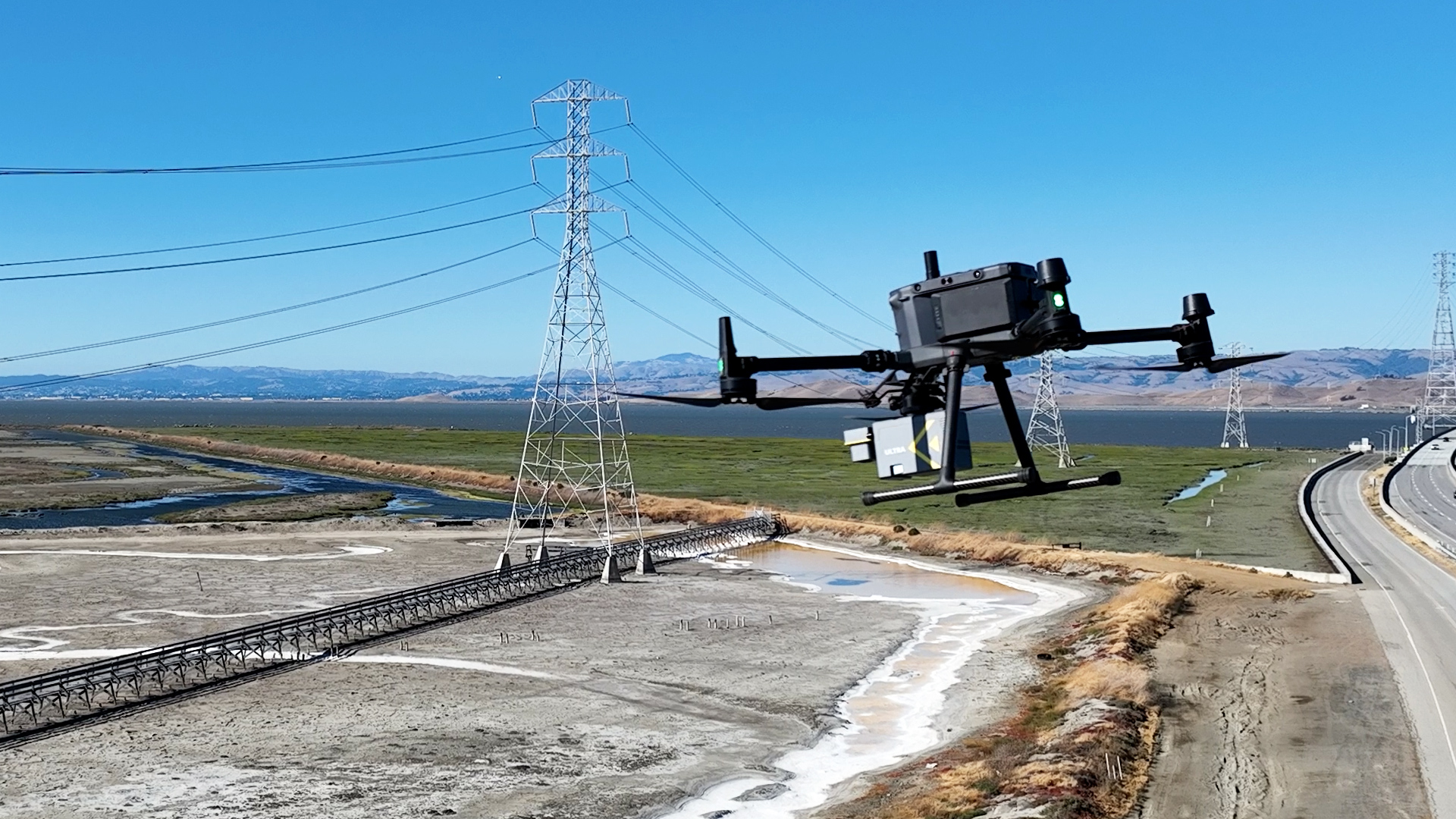
Flying 120 meters above the pit let us stay clear of hazards like walls and power lines.
— Jeffrey Wannop, Senior Geologist & UAV Pilot
Flight Plan and Data Capture
Launching from a safe vantage point, Jeffrey Wannop piloted the ROCK Ultra at 120 meters AGL, flying at an average speed of 11–12 m/s.
That altitude provided complete coverage of the pit’s vertical walls while keeping the aircraft above power lines and other on-site infrastructure.
Despite the higher altitude, the system captured dense, accurate point returns all the way to the bottom of the pit, revealing precise bench edges, haul roads, and even 300-ton truck dumps visible within the stockpiles.
Even flying from higher elevation, we were getting point returns all the way to the bottom.
— Jeffrey Wannop
Results: Crisp Data, Efficient Workflow
The ROCK Ultra’s performance exceeded expectations in both efficiency and data fidelity.
The mine’s surface model revealed crisp, detailed benches and accurate volume calculations for monthly production tracking.
Data alignment between multiple pits was seamless—requiring minimal post-processing and zero manual adjustment.
Capturing good quality, good density data right to the bottom of the pit from flying at the top—very, very much impresses me.
— Keith Seidler
Even with the increased altitude, the Ultra’s 7-return LiDAR provided enough density to detect micro-topographic details, from switchback roadways to stockpile texture.
Processed by the ROCK Customer Success & Pro Services Team
Once the flights were complete, the dataset was processed by Jamie Lackner and the ROCK Customer Success & Pro Services team.
The data required minimal manipulation thanks to the clean, uniform collection—turnaround time was drastically reduced.
It was a quick process and a very clean dataset. The mission planning and the way you flew it came out with such a stunning model that I had to do very little manipulation after the fact.
— Jamie Lackner, ROCK Pro Services Manager
See the Stunning Dataset
Final Thoughts: Safety, Scale, and Speed in One System
Mapping deep open-pit environments requires a balance of safety, precision, and efficiency.
The ROCK Ultra LiDAR delivered on all fronts—enabling Keith and Jeffrey to fly higher, stay safer, and still capture the granular detail their operation depends on.
Disclosure
The test site featured in this case study is an active open-pit copper mine located in British Columbia, Canada.
The operating company has requested anonymity.
Field testing conducted by Keith Seidler (Chief Geologist) and Jeffrey Wannop (Senior Geologist & UAV Pilot).