How the ROCK R3 Pro Helped “Mystery at Blind Frog Ranch” See Beneath the Surface
Aug 07, 2025
The Discovery Channel series Mystery at Blind Frog Ranch follows Duane Ollinger and his team as they search for a legendary Aztec treasure hidden somewhere on a remote property in Utah’s Uinta Basin. Season 4’s episode “The Skull” introduces geologist Eric Drummond, who believes the key to solving the mystery lies in understanding the ranch’s complex network of caves and fault lines. To do that, he turns to LiDAR. This article explains how Rock Robotic’s R3 Pro V2 LiDAR system—though not named on air—embodies the technology deployed on the show and why its capabilities were critical to the investigation.
Why Blind Frog Ranch Needed LiDAR
After a partial collapse of the South Cave cut off the team’s main access point to the underground caverns, Drummond suggested a new approach. He told Duane and the rest of the crew that many of the world’s largest caves follow geological fault lines. Because Blind Frog Ranch sits atop a web of faults, he proposed scanning the property with LiDAR to look for an open‑air entrance they might have missed. Conventional exploration would have been dangerous, time‑consuming and imprecise; a precise 3‑D map from the sky promised a safer, data‑driven way to spot anomalies.
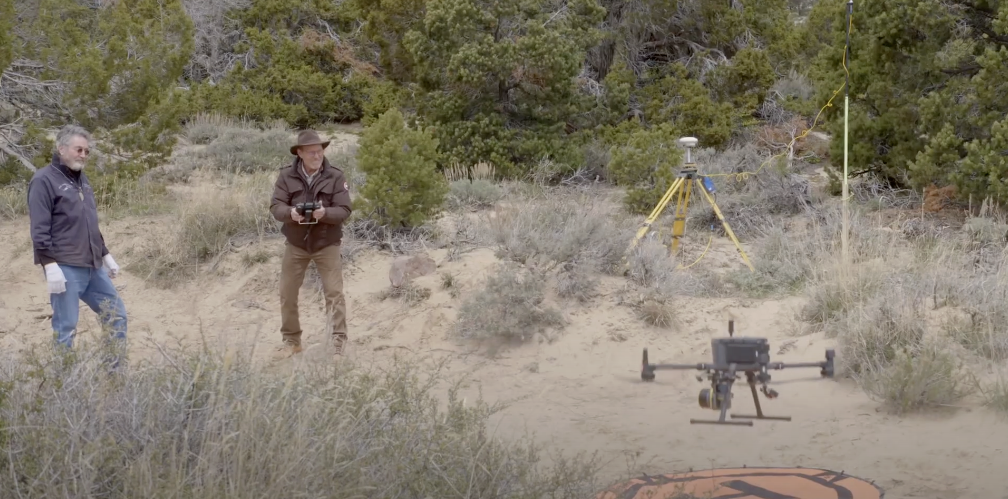
Taking to the Air
Later that day, Drummond and Ollinger launched a LiDAR‑equipped drone to map the ranch. Drummond pre‑programmed the craft to fly a grid pattern across several acres, effectively blanketing the search area. The R3Pro LiDAR system captured dense point‑cloud data that showed subtle variations in elevation and surface texture. Within minutes of landing, the team reviewed the results and noticed a bare spot along one of the fault lines—an area devoid of vegetation that might indicate human disturbance or an opening. Drummond suspected it could be an open‑pit mine and insisted on a field investigation. When the crew hiked to the location, they discovered timbers, malachite (green copper ore) and hematite (brown iron oxide), confirming they had found an abandoned mine. This simple LiDAR flight redirected the search and uncovered part of the ranch’s history.
Uncovering Hidden Faults
In subsequent episodes, the LiDAR data continued to reveal patterns invisible from ground level. Warner Bros. Discovery’s press release for the season notes that LiDAR scans exposed a fault line that connects several locations on the ranch and beyond. That insight gave the team a new theory: the cave they were seeking might lie along this fault, accessible through a different entrance. Without high‑resolution 3‑D mapping, this fault‑line connection would have remained a guess. Accurate LiDAR gave the team the confidence to mobilize heavy equipment and explore the right areas.
Why the ROCK R3 Pro Was the Perfect Tool
The ROCK R3 Pro LiDAR system provided exactly the kind of advanced scanning needed for Blind Frog Ranch’s challenges. This 32-channel LiDAR unit can capture up to 1.28 million data points per second, producing an exceptionally dense point cloud of the terrain. Such high resolution was crucial for detecting subtle depressions or linear features (like a trench or shaft opening) that might indicate underground voids. Moreover, the R3 Pro delivers survey-grade accuracy on the order of a few centimeters, thanks to its triple-band GNSS receiver and tactical-grade IMU. The team could trust that an anomaly seen in the LiDAR map was in the correct location when they went to investigate on foot – a critical factor when you’re trekking to a specific spot in the wilderness.
Equally important was the R3 Pro’s versatility and ease of deployment. Weighing only ~1.3 kg and designed to mount on standard drones, the R3 Pro was easily carried up to the remote mountain areas and flown over the ranch’s rugged landscape. In a single flight, it could scan dozens of acres in minutes – far faster and safer than any ground survey over the same steep terrain. The unit’s 360° field of view and dual-return lasers meant it captured everything from tall sagebrush and rocks to the ground surface beneath them. This ability to “see through” sparse vegetation ensured that no potential cave entrance or sinkhole was missed due to ground cover. After flights, the collected LiDAR data was processed through Rock Robotic’s software to create 3D maps that the team could examine for patterns (like the continuous fault line) or voids. The quick turnaround from data collection to visualization meant the crew could act on the insights immediately, adjusting their dig plans based on the latest scans.
Another advantage of using the R3 Pro was the safety factor. Many areas of interest – such as old mine shafts, cliffside caves, or the interior of a collapsed cavern – were extremely dangerous for a person to explore directly. By scanning these zones remotely, the team obtained critical information with zero risk to human life. As noted on social media, this was a “brilliant & safer strategy” to approach targets like the underwater cave chamber thought to hold a treasure box. The LiDAR could outline the shape and depth of a cave or void before anyone ever attempted to enter, allowing the crew to prepare proper safety measures. In essence, the R3 Pro acted as the scouts’ eyes, venturing into perilous areas via laser beams so that the explorers could proceed with caution and knowledge. It’s a perfect example of technology making exploration not only more effective but also safer.
Lessons for Surveyors and Explorers
The Blind Frog Ranch team’s experience illustrates the power of modern LiDAR. Without disturbing the land or risking additional cave‑ins, they acquired a detailed digital twin of the property, located a previously unknown mine and charted fault lines. Surveyors, civil engineers and geologists can draw similar lessons:
- Use LiDAR to augment intuition. Even veteran geologists like Eric Drummond rely on data to test hypotheses. LiDAR can quickly confirm or refute hunches about structures, faults or human activity.
- Don’t underestimate point‑cloud density. The R3 Pro’s high pulse rate captured minor changes in vegetation and surface roughness—subtle cues that led to the discovery of the bare spot. Lower‑resolution sensors might have missed it.
- Integrated software accelerates decisions. Immediate field QA and cloud‑based deliverables let the Blind Frog team pivot quickly. In commercial projects, this translates to fewer site revisits and faster turnaround.
Conclusion
The hunt for treasure at Blind Frog Ranch made for great television, but it also highlighted a real‑world problem: how do you safely and efficiently map complex terrain? LiDAR provided the answer. By flying a LiDAR‑equipped drone over the property, the team identified hidden features, uncovered an old mine and traced fault lines that could lead to undiscovered caverns. The capabilities showcased on the show align with Rock Robotic’s R3 Pro V2—a versatile, high‑accuracy LiDAR platform that surveyors and explorers can deploy from the air, on a vehicle or on foot. If you’re facing a mapping challenge that demands centimeter‑level precision and multi‑mission flexibility, the R3 Pro offers a proven solution.