The Hidden Cost of Cheap LiDAR: What Spec Sheets Won't Tell You
Apr 01, 2026
The DJI Zenmuse L3 changed the conversation.
$17,400 for a 1535 nm sensor with 2 million points per second, 16 returns, and dual 100 MP cameras. Specs that cost ten times more just two years ago. When the L3 dropped in November 2025, every survey firm in the industry suddenly had the same conversation: "Why would I spend more than this?"
It's the right question to ask. It's the wrong frame to answer it in.
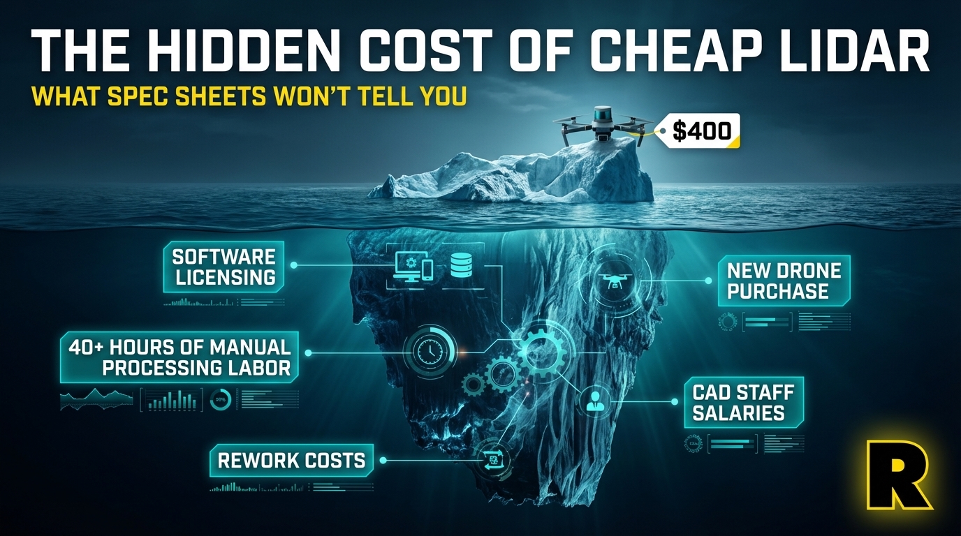
Sensor purchase price is a single line item in a spreadsheet that has a dozen more lines your LiDAR salesperson won't show you. Total cost of ownership — what you actually spend over three years to collect, process, and deliver LiDAR surveys — tells a completely different story.
This post is that story.
The Spec Sheet Trap
Spec sheets show sensor price. They don't show:
- The cost of software licenses required to process the data
- The labor hours required per project to go from raw LiDAR to deliverable
- The cost of rework when data quality doesn't meet client specs
- The platform cost (do you need a new drone?)
- The support cost when something goes wrong in the field
- The opportunity cost of project types you can't take on
A $17,400 sensor paired with 40 hours of manual processing labor per project costs more per deliverable than a higher-priced sensor that cuts that to 4 hours with automated processing.
Let's run the numbers.
The Real 3-Year TCO Comparison
Scenario: A Survey Firm Doing 50 Projects Per Year
System A: DJI L3 on M400 (New Drone Required)
| Cost Item | Year 1 | Year 2 | Year 3 | Total |
|---|---|---|---|---|
| DJI L3 sensor | $17,400 | — | — | $17,400 |
| DJI M400 drone (required) | $16,000 | — | — | $16,000 |
| DJI Terra Pro (or Terra + Modify) | $999–$2,040 | $999–$2,040 | $999–$2,040 | $3,000–$6,120 |
| Processing labor (40 hrs/project × $75/hr × 50 projects) | $150,000 | $150,000 | $150,000 | $450,000 |
| 3-Year Total | ~$490,000 |
System B: ROCK Ultra on Existing M350 + ROCK Pro Services
| Cost Item | Year 1 | Year 2 | Year 3 | Total |
|---|---|---|---|---|
| ROCK Ultra sensor | (contact for pricing) | — | — | ROCK price |
| M350 drone | Already owned | — | — | $0 |
| ROCK Desktop renewal | Annual fee | Annual fee | Annual fee | 3× annual |
| ROCK Cloud + Pro Services (50 projects) | Per-project fee | Per-project fee | Per-project fee | 3× annual use |
| Processing labor (4 hrs/project × $75/hr × 50 projects) | $15,000 | $15,000 | $15,000 | $45,000 |
| 3-Year Total | Substantially lower |
The numbers are intentionally directional — actual ROCK pricing varies by configuration and Pro Services usage. But the structure of the comparison is clear: the labor cost of manual processing dwarfs sensor purchase price over any meaningful time horizon.
If a firm does 50 survey projects per year and each requires 40 hours of manual classification, feature extraction, and CAD drafting at $75/hr, that's $150,000 per year in processing labor alone. Over three years, that's $450,000 — paid whether or not the sensor cost $17,400 or $80,000.
ROCK Pro Services replaces those 40 hours with a few hours of upload and review, at a fraction of the labor cost. The economics flip.
The Processing Labor Reality
Here's what a typical LiDAR workflow looks like after a flight with a "basic" processing system:
- Strip alignment — manual or semi-automated. Time: 1-4 hours depending on flight complexity.
- Ground classification — manual editing of automated results. Time: 2-6 hours for a complex site.
- Feature extraction — identifying and drawing breaklines, planimetric features. Time: 4-16 hours.
- CAD drafting — taking extracted features into CAD for deliverable production. Time: 4-20 hours.
- QC and client revisions — Time: 1-4 hours.
For a mid-complexity survey project, 15-40 hours of skilled labor between flight and deliverable is common. At market rates for a qualified LiDAR technician or surveyor, that's real money on every single project.
ROCK Cloud automates steps 1-3. ROCK Pro Services covers 1-5. The processing labor line item shrinks dramatically — or disappears from your payroll entirely.
Sunrise Engineering used ROCK Pro Services to eliminate the need for a dedicated CAD technician on their drone LiDAR projects, turning around deliverables faster and at lower cost per project than their previous all-in-house approach.
The Platform Cost Hidden in the Fine Print
The DJI L3 is $17,400. But you can't fly it on the M350 you already own.
The L3 requires the DJI M400 — a new drone that costs approximately $16,000+ to purchase. For a firm with an existing M350 fleet, the true cost of the L3 is $17,400 + $16,000 = $33,400+ before you fly a single project.
Plus: a new drone means new training, new maintenance procedures, new insurance documentation, and a new operational workflow for your team. None of those cost zero.
Compare to the ROCK Ultra, which mounts directly on your M350 via DJI SkyPort — no new drone, no new training, no operational overhead.
The Rework Cost Nobody Talks About
Every LiDAR survey has a probability of requiring rework — data quality issues, accuracy that doesn't meet client specifications, processing errors that require a re-flight.
With a survey-grade system and a verified workflow (like ROCK Cloud's automated QC), rework rates are low. With a system at the edge of its capability on a demanding project, rework becomes a real business cost.
A re-flight on a 500-acre project can cost $2,000-$5,000 in operational time, drone costs, and field crew. On a time-sensitive contract, it can mean a penalty clause.
The "cheaper" sensor that produces slightly lower quality data — or that requires manual processing steps that introduce human error — doesn't just cost more in labor. It costs more in rework risk on every project.
The Market Access Cost: What Cheap LiDAR Locks You Out Of
Here's a cost that never appears on a spec sheet: the revenue you can't generate because your equipment fails a compliance check.
If the DJI L3 on the M400 is your platform, you cannot bid:
- Federal agency survey contracts (NDAA non-compliant)
- State DOT projects with NDAA requirements
- Utility infrastructure work for regulated utilities
- Military installation surveys
- Any federally funded project with supply chain requirements
These aren't hypothetical future contracts. For many regional survey firms, government and infrastructure work represents 30-50% of total revenue opportunity.
A "cheaper" sensor that forecloses that market segment isn't cheaper. It's more expensive — measured in the contracts you'll never bid.
The Versatility Multiplier
A drone-only LiDAR sensor — whether the L3, the EchoONE, or the YellowScan Surveyor Ultra — addresses one category of project. Aerial survey.
The ROCK R3 Pro V2 addresses three:
- Aerial survey (drone)
- Mobile corridor mapping (vehicle mount)
- GPS-denied capture (SLAM handheld)
For a survey firm spending $35,000–$50,000 on a LiDAR system, the addressable market for a three-mode system is dramatically larger than for a single-mode sensor.
More project types from the same hardware investment means a faster payback period and a higher lifetime return. That's the versatility multiplier.
The Support Cost Nobody Budgets For
Every LiDAR deployment eventually produces a problem you haven't seen before. A strip alignment anomaly. A PPK convergence issue. An unexpected artifact in the point cloud. A firmware update that changes a processing workflow.
When that happens on a job deadline, the value of being able to call a practitioner who has seen that exact problem — and can talk you through a solution in 15 minutes — is not zero.
ROCK's support team uses this equipment in the field. The Indiana Drones YouTube channel (150K+ subscribers) provides the largest library of practical LiDAR troubleshooting and workflow guidance in the industry. Harrison and the team are accessible in ways that DJI enterprise support, YellowScan's European team, or CHCNAV's Asia-Pacific operation simply aren't.
Budget for support. It will come up.
The Right Frame for the Decision
Buying drone LiDAR isn't like buying a camera or a drone. It's buying a production system that will generate revenue (or not) on every project you take on for the next 3-5 years.
The right questions:
- What is my total cost per deliverable over three years? (Not just sensor cost)
- What is my addressable market with this system? (Not just what it can fly)
- What is my rework risk per project?
- What happens when something goes wrong on a $75K project?
- What project types am I turning down that this system could capture?
Sensor purchase price answers none of those questions. Total cost of ownership answers all of them.
Subscribe to Indiana Drones on YouTube to see real survey firms building real LiDAR businesses — with the actual cost and workflow numbers they use.