Surveying Hawaii’s Dense Jungle with Aerial LiDAR Mapping: A ROCK Ultra Case Study
Sep 10, 2025
Unlocking the Secrets of Hawaii’s Dense Jungle with ROCK Ultra LiDAR
Hawaii's lush, dense jungles present an formidable challenge for traditional surveying and mapping methods. The thick canopy and complex terrain often obscure the ground, making it difficult to capture accurate data. However, the ROCK Ultra LiDAR system, as showcased in a recent case study and demo tour, is changing the game by delivering unparalleled data quality and efficiency even in these most challenging environments. Join us as we delve into how this cutting-edge drone LiDAR technology is revolutionizing aerial mapping in Hawaii.
The Challenge: Dense Vegetation and Complex Terrain
Aerial LiDAR specialist Mike Elliott of Drone Services Hawaii, in collaboration with the ROCK Robotic team, put the ROCK Ultra LiDAR to the ultimate test in Hawaii. The mission involved mapping vast areas with dense vegetation, encountering significant line-of-sight issues, and operating at altitudes up to 400 ft AGL. The goal was to demonstrate how the ROCK Ultra could overcome these obstacles and provide precise, survey-grade data.
Unmatched Performance: Key Highlights from the Case Study
The case study video highlights several remarkable achievements of the ROCK Ultra LiDAR system in action [1]:
- Efficient Area Coverage: The system successfully mapped an impressive 191 acres in a single 17-minute flight, drastically reducing the need for multiple relocation points and saving valuable time in the field.
- Deep Canopy Penetration: Leveraging its advanced seven-return LiDAR system, the Ultra demonstrated exceptional ability to penetrate Oahu’s thickest canopies, capturing crucial data often missed by less sophisticated systems.
- Highly Detailed Surface Models: Despite the dense vegetation, the ROCK Ultra delivered a highly detailed surface model of one of Hawaii’s densest valleys. This level of detail even extended to revealing subtle features like building footprints, detailed rooftops, and statues hidden beneath the heavy foliage.
- Survey-Grade Clarity for Infrastructure: The project successfully mapped a stream corridor, providing survey-grade clarity essential for an upcoming sewer project.
- Colorized Point Clouds in Challenging Conditions: Even under cloudy conditions, the system produced a bright, colorized point cloud, ensuring comprehensive data visualization.
- On-the-Fly Flight Planning: The team showcased the flexibility of the system by testing an on-the-fly flight plan created entirely in the field using Pilot 2 software.
- Streamlined Workflow: Post-processing was significantly streamlined with ROCK Desktop and ROCK Cloud, reducing desk work and accelerating project completion.
- Superior Performance: A direct comparison with the ROCK R3 Pro emphasized the Ultra's strengths in large-area, high-altitude mapping.
Introducing the ROCK Ultra LiDAR: The 'Easy Button' for Pro LiDAR
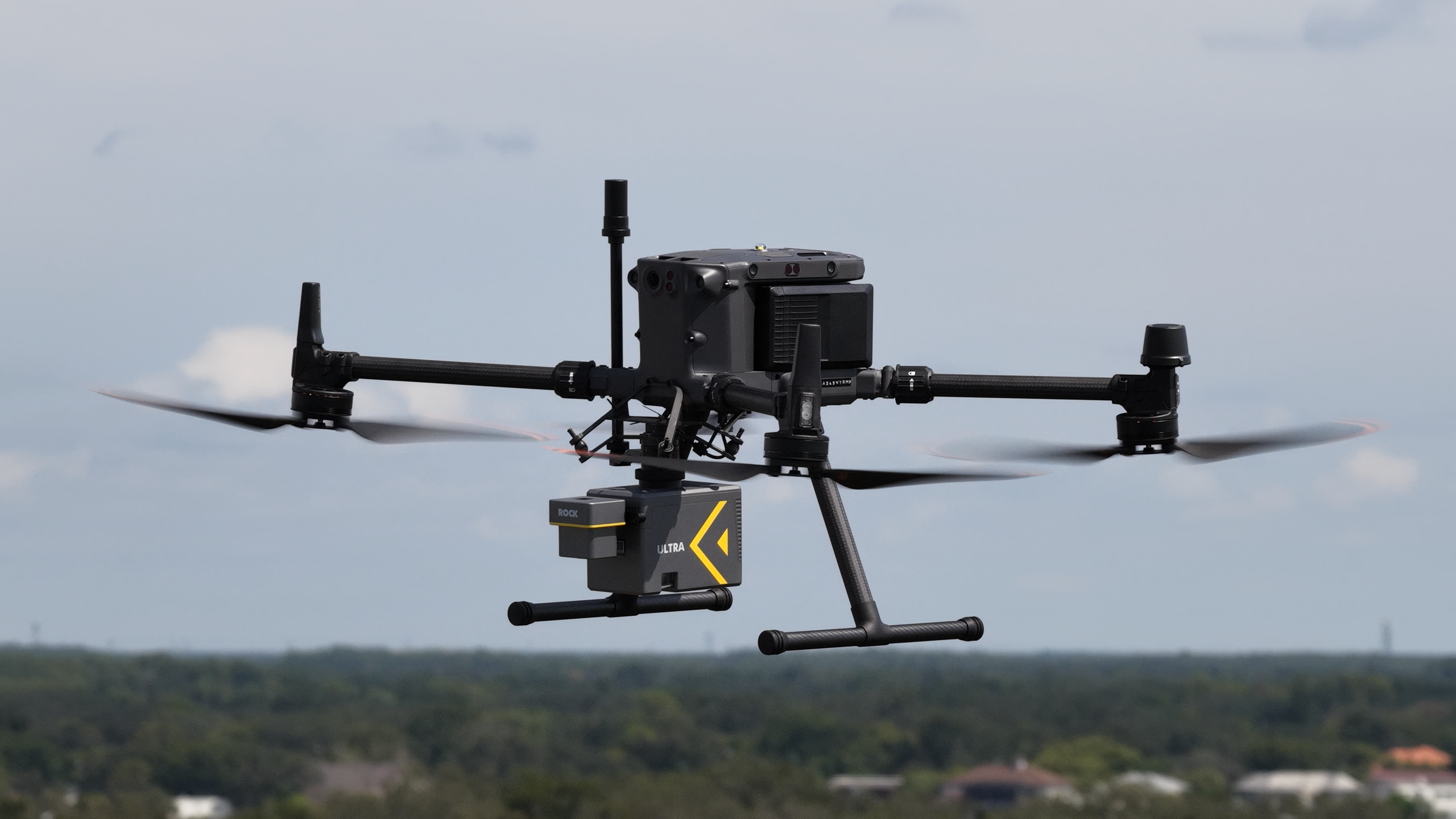
The ROCK Ultra LiDAR is a next-generation aerial LiDAR sensor meticulously engineered for high-efficiency mapping and exceptional vegetation penetration. This flagship long-range system allows users to fly higher and faster, covering 2-3 times more ground per flight compared to other systems, all while maintaining superior data quality.
Services and Capabilities:
- Industry-Leading 7 Returns Per Pulse: With seven echo returns, the highest in the UAV LiDAR industry, the Ultra's powerful 1550nm laser penetrates even the densest canopies to capture true ground data where other systems fail. This ensures reliably clean bare-earth models, minimizing manual classification and repeat flights.
- Extended Range and Altitude: Boasting a 1000m effective range and a maximum altitude of 450m AGL, the Ultra simplifies mission planning over complex terrain and mitigates risks from unmapped obstacles. Users can confidently fly at maximum legal altitude (400ft / 120m AGL).
- Enhanced Safety and Data Quality: The 1550nm wavelength is 40 times safer than 905nm systems, allowing for higher power output without eye safety concerns. This also translates to 17 times more photons, resulting in a better signal-to-noise ratio in bright sunlight, and a 4 times smaller spot size for higher ground resolution at 100m. It is Class 1 eye-safe, making it FAA approved for operations near airports.
- End-to-End Ecosystem Integration: The Ultra seamlessly integrates into the ROCK workflow. Data can be pre-processed in the field using ROCK Desktop, then uploaded to ROCK Cloud for storage, analysis, and ordering professional deliverables like DTMs, contours, and planimetrics with a single click.
- Lightweight Design: At just 1.21kg (sensor only) or 1.40kg with a 26MP camera, the Ultra is 60% lighter than comparable long-range systems, ensuring excellent flight performance.
The ROCK Ultra is a complete solution, ready to fly out of the box, and includes the LiDAR unit, a durable Pelican case, a calibrated 26MP or 45MP camera, a 256GB high-speed USB drive, a Gremsy universal mount for DJI M300/M350, a ROCK Cloud subscription, ROCK Desktop software, comprehensive training & certification, and direct access to U.S.-based technical support.
Explore the Hawaii Dense Jungle Dataset
Curious to see the raw data from this incredible case study? You can explore the actual point cloud dataset captured in Hawaii’s dense jungle.
Ready to Transform Your Mapping Workflow?
The ROCK Ultra LiDAR system is designed to empower professionals in land surveying, forestry management, civil engineering, and more to tackle even the most challenging projects with unmatched efficiency and precision.