Enhancing Aerial LiDAR with Multiple Returns: A White Paper
Jul 29, 2025
By Alex Knoll, CTO
Executive summary
LiDAR (light detection and ranging) has become a cornerstone of modern aerial surveying because it can produce highly accurate three‑dimensional models regardless of lighting conditions. Traditional discrete‑return LiDAR sensors recorded only the first and last return from each laser pulse, so information about intermediate canopy layers was lost. Over the last decade, advances in receiver electronics and waveform processing have made it possible to record multiple returns from a single pulse. Today’s airborne LiDAR sensors can extract up to seven returns, enabling unprecedented insight into vegetated environments and complex built structures.
This white paper explains how LiDAR returns are generated, why multiple returns are advantageous for UAV‑based mapping, and how many of these benefits scale with the number of returns captured. It concludes with an overview of the ROCK Ultra – a survey‑grade, drone‑optimised LiDAR system developed by ROCK Robotic that captures seven returns per laser pulse. The system delivers dense ground points even through dense forest canopy and integrates seamlessly with the ROCK ecosystem to provide an “easy button” workflow from data collection through deliverables.
1 Understanding LiDAR returns
1.1 How LiDAR works
LiDAR instruments emit short laser pulses and measure the time needed for each pulse to travel to a target and back to the sensor. By combining the measured distance with the instrument’s position and orientation (from an inertial measurement unit and GNSS), each return is converted into a three‑dimensional point. A collection of such points forms a point cloud.
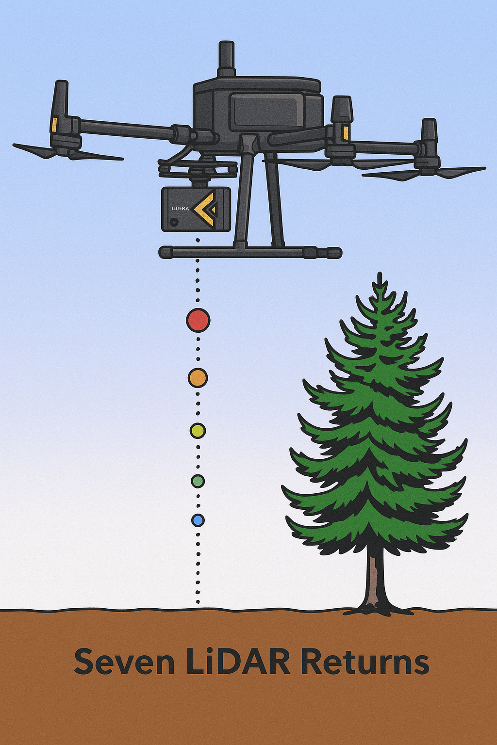
A discrete‑return LiDAR system identifies one or more reflections from a single pulse. The first return usually originates from the topmost surface (tree canopy, building roof, etc.), intermediate returns come from objects between the canopy and the ground, and the last return is often the ground. Early systems could only record the first and last returns, but modern instruments can extract several reflections separated by as little as a few meters of range.
1.2 Number of returns
The number of returns per laser pulse is determined by the sensor’s digitization electronics and the pulse’s ability to penetrate the target. For most small‑footprint airborne LiDAR systems, the maximum number of returns is four or five. Recent innovations in long‑range airborne scanners – including the ROCK Ultra – have pushed this boundary to seven returns. Each return is tagged with a return number (e.g., 1 of 4, 2 of 4) for subsequent classification.
2 Why multiple returns matter in aerial/UAV LiDAR
2.1 Enhanced canopy penetration and ground detection
Multiple returns enable LiDAR to “see” through vegetation by recording successive reflections as the laser pulse passes through gaps in leaves and branches. Educational resources from Humboldt State University explain that multiple‑return LiDAR allows the separation of the bare terrain from surface features: a single pulse may reflect from the upper, middle and lower tree canopy as well as the ground. Because each reflection has its own X, Y and Z coordinate, algorithms can classify points into canopy layers and ground, enabling accurate digital elevation models (DEM) even in dense forests.
NOAA’s Lidar 101 guide notes that the ability to discern multiple returns is a major technological advance: modern systems can provide at least three returns per pulse, whereas early systems recorded only first and last returns. The middle returns are rarely ground points and are typically attributed to vegetation, while last returns are more likely to be from the ground.
2.2 Improved accuracy of elevation models
Capturing multiple returns improves the accuracy of DEMs and surface models. When only a single return is recorded, the instrument must assume whether it represents the ground or an object. With multiple returns, algorithms can filter out non‑ground points and retain only last returns to generate bare‑earth models. A University of Humboldt reference notes that modern systems can record up to five returns, providing the information needed to separate terrain from vegetation and reduce elevation errors on steep slopes.
NOAA also shows that surfaces created using only first or last returns can be noisy or incomplete; classification using all returns typically produces the most accurate bare‑earth data.
2.3 Detailed object classification and vegetation analysis
Each return carries intensity and return‑number information. These attributes aid in the classification of points into ground, vegetation buildings and other objects. Multi‑return LiDAR is therefore essential for forestry, biomass estimation and habitat studies, where analysts need to understand canopy height, crown density and understorey structure. The ability to analyse intermediate returns helps researchers quantify biomass, estimate canopy closure and identify vegetation encroachment on utility corridors.
2.4 Higher density of usable points
Multiple returns increase the number of useful ground points. A LIDAR Magazine article explains that multi‑return scanners detect elevations of several objects and surfaces on and above the ground; by penetrating vegetation, they generate a denser set of usable points compared with single‑return systems. The article recounts a rail survey where multiple returns greatly increased the density of useable ground points, enabling accurate mapping under dense vegetation.
3 Scaling up: benefits of seven returns
While most airborne LiDAR systems capture 3–5 returns, the ROCK Ultra records ≥7 returns. The advantage of seven returns is straightforward: more reflections increase the probability of receiving a ground hit when the canopy is extremely dense or the terrain is complex.
3.1 Why seven returns matter for UAV operations
UAV‑borne LiDAR sensors operate at lower altitudes and lower pulse energies than manned‑aircraft systems, so the ability to collect additional returns is important when flying over dense forests or under high‑altitude operating envelopes. More returns increase the effective “sampling depth” of each pulse, improving the probability of obtaining ground returns even when the laser pulse is partially attenuated by leaves or branches. This capability reduces the need for repeat flights, decreases post‑processing effort to fill holes, and ultimately leads to more accurate deliverables.
4 The ROCK Ultra: seven‑return LiDAR optimized for drones
ROCK Robotic’s ROCK Ultra is a next‑generation UAV LiDAR system engineered specifically for large‑scale mapping projects. It combines a long‑range 1550 nm laser, tactical‑grade IMU and a 90° field of view in a lightweight (1.4 kg with camera) package. Key benefits include:
- Long‑range performance – The 1550 nm laser delivers a measurement range of 500 m at 20 % reflectivity and 1 000 m at 80 % reflectivity, enabling flights at 450 m AGL while maintaining survey‑grade data quality.
- High pulse rate and data density – The sensor fires up to 1 million pulses per second with all energy directed downward across a 90° FOV. This creates a point cloud over three times denser than typical 360° scanners at the same pulse rate.
- 7 returns per pulse – The ROCK Ultra can record up to seven returns from a single pulse. This capability, combined with the long‑range 1550 nm wavelength, ensures superior vegetation penetration and reliable ground detection under dense canopy. In essence, the Ultra captures more ground points where other UAV sensors might return only canopy points.
- Tactical‑grade IMU and GNSS – The system uses a tactical‑grade IMU (0.006° pitch/roll, 0.03° heading) and multi‑constellation GNSS (GPS, GLONASS, Galileo, BDS) with PPK post processing. Post‑processed positional accuracy reaches 1 cm horizontal and 2 cm vertical.
- Lightweight design – Weighing 1.21 kg (sensor only) or 1.40 kg with a 26 MP camera, the Ultra is one of the lightest long‑range LiDAR sensors available. Its low weight allows longer flight times and compatibility with standard UAV platforms.
- Integrated software ecosystem – The Ultra integrates seamlessly with ROCK Desktop, ROCK Photogrammetry and ROCK Cloud. After a flight, users can perform field QA in ROCK Desktop, upload data to the cloud for automated classification and deliverable generation, and order professional deliverables such as DTMs, contours and planimetrics.
4.1 Operational advantages
Operating at higher altitudes with seven returns provides tangible benefits:
- Simple mission planning – Because the Ultra can be flown at 400 ft (120 m) or higher, obstacles such as trees, power lines and towers become irrelevant in the flight plan. This simplifies planning and reduces risk.
- Reduced field time – High‑altitude flights cover 2–3 times more area per flight than traditional systems. Combined with high point density and deep canopy penetration, this translates into fewer passes and less total flight time.
- Scalability and training – The ability to fly simple grid patterns at high altitude makes LiDAR accessible to less‑experienced pilots. Training times are shorter, allowing organisations to scale their survey operations more easily.
- Improved deliverables – Seven returns ensure that the resulting point cloud contains sufficient ground points to generate accurate DEMs and feature extractions without labour‑intensive manual editing. Clients see crisp bare‑earth surfaces and detailed planimetric features even in challenging environments.
4.2 Comparison with conventional UAV LiDAR
While entry‑level sensors such as DJI’s Zenmuse L2 (with up to five returns) are excellent tools for basic surveys, they lack the range and penetration needed for large‑scale or densely vegetated projects. Premium systems like the RIEGL VUX‑240 or YellowScan Voyager can capture more returns but are heavy and expensive, often requiring specialized aircraft. The ROCK Ultra strikes a balance: it delivers 7‑return capability, long range and high accuracy in a 1.4 kg UAV‑optimised package. This combination makes the Ultra particularly attractive for organizations that need both efficiency and data quality without the complexity and cost of heavy‑lift systems.
5 Conclusion
The ability to capture multiple returns from each LiDAR pulse is one of the most significant advances in aerial surveying. Multiple returns enhance canopy penetration, improve digital elevation models, support detailed object classification and deliver higher densities of usable ground points. Sensors capable of seven returns push these benefits further by increasing the likelihood of obtaining ground points in dense forests and complex environments.
As a surveyor or mapping professional, choosing a LiDAR system with the right number of returns is critical. The ROCK Ultra demonstrates how a lightweight, drone‑optimized sensor can leverage seven returns, a long‑range 1550 nm laser and a tactical‑grade IMU to deliver survey‑grade data with minimal field effort. Through its integrated software ecosystem, the Ultra provides an “easy button” workflow from flight planning to final deliverables. For large‑scale projects where efficiency and vegetation penetration are paramount, investing in a seven‑return UAV LiDAR system like the ROCK Ultra can yield faster surveys, deeper insights and better bottom‑line results.