Explore the DJI Zenmuse L3 Rolling Hills Dataset: Premium LiDAR Data on ROCK Cloud
Nov 11, 2025
Experience the precision and clarity of DJI Zenmuse L3 LiDAR through our Rolling Hills sample dataset—available to explore, analyze, and download directly on ROCK Cloud.
🎯 Interactive Dataset Gallery
🚀 Explore the Dataset Now
What you'll see: Interactive 3D LiDAR data with RGB overlay, elevation mapping, and professional deliverables—all in your browser. No software to install, just click and explore.
Ready to try it yourself? Get a free 14-day trial with 5 GB of upload space—no credit card required.
About This Premium Dataset
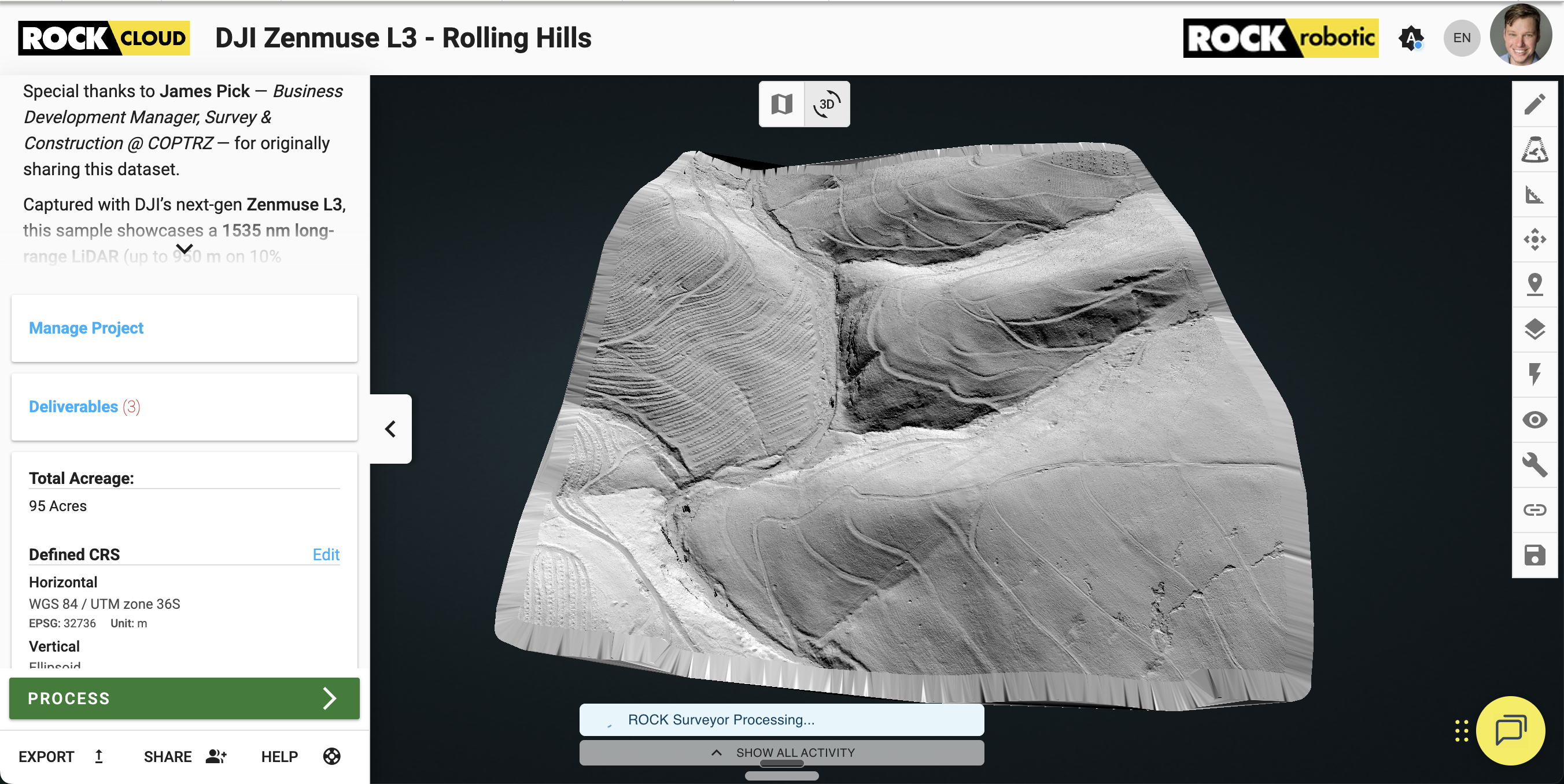
Special thanks to James Pick, Business Development Manager for Survey & Construction at COPTRZ, for sharing this real-world dataset captured with the DJI Zenmuse L3.
The Rolling Hills scene covers:
- Terraced farmland with smooth contour transitions
- A winding creek bed and ravine lined with trees and dense vegetation
- Open fields and mixed terrain perfect for testing canopy penetration and elevation accuracy
This dataset highlights what today's DJI Zenmuse L3 can do—and how ROCK Cloud makes those results accessible, shareable, and ready for processing.
Why ROCK Cloud Makes L3 Data More Valuable
Most drone pilots stop at processing in DJI Terra. ROCK Cloud takes you further: it turns that dataset into a web-based workspace for collaboration and professional deliverables.
Here's what happens once your L3 data hits ROCK Cloud:
✅ Instant 3D access – Upload .laz files and start exploring immediately, with RGB, intensity, and elevation layers.
✅ Shareable projects – Send clients a link they can open in any browser—no downloads, no viewer installs.
✅ Professional analysis – Measure, calculate volumes, compare flights, and export subsets in seconds.
✅ 1-click deliverables – Order ROCK Pro Services to transform your data into contours, DTMs, planimetrics, or vegetation reports overnight.
In short: ROCK Cloud turns your LiDAR from a dataset into a deliverable.
Terrain Highlights
The Rolling Hills project is a perfect stress test for the DJI Zenmuse L3—and an ideal example of how ROCK Cloud handles complex surfaces.
- Farmland & slopes – Consistent density and smooth elevation models make contouring effortless.
- Creek corridor – Multi-return data cleanly separates canopy from ground, visible in intensity view.
- Vegetation detail – 1535 nm wavelength captures through brush for accurate bare-earth mapping.
- Ravine modeling – High-precision returns reveal subtle grade breaks ideal for DTM generation.
These features will soon be processed through ROCK Pro Services to generate full DTM + contour deliverables for download—straight from this same project page.
See the Data, Then See the Deliverable
We're processing this dataset through ROCK Pro Services to create:
- Contours (1 ft / 2 ft)
- Digital Terrain Model (DTM)
- Breaklines along the creek and terrace edges
Once complete, you'll be able to view the before-and-after results right here on ROCK Cloud.
The same workflow you'll use for your own projects: upload → visualize → order deliverables → download CAD-ready results.
Additional Dataset Views
Precision Performance: DJI Terra Quality Report
The Rolling Hills dataset demonstrates exceptional accuracy and consistency. According to the comprehensive DJI Terra processing report, the L3 achieved:
Data Quality Metrics:
- POS Fix Rate: 100% (no data gaps)
- Point Cloud Density: 349 points/m² average, exceeding standard requirements
- Processing Efficiency: 7 hours 12 minutes total processing time
- Ground Classification: Automated with gentle slope parameters
Technical Parameters:
- Pulse Rate: 1,000 kHz
- Scan Rate: 16,000 kHz
- Field of View: 80° × 3°
- Scan Mode: Linear
- Ground Point Density: 285 points/m² after classification
This level of precision makes the dataset ideal for survey-grade applications including topographic mapping, drainage design, and infrastructure planning.
Start Hosting Your Own L3 Data
You can do everything shown here—today.
ROCK Cloud is built for:
- Any LiDAR dataset - aerial, mobile, terrestrial scanners, SLAM
- DJI Zenmuse L3, ROCK R3 Pro V2, and ROCK Ultra data
- Orthomosaics and image datasets with trajectory data
- Gaussian splats (coming soon)
- Fast, browser-based collaboration
- Secure sharing with branding
- On-demand professional processing
ROCK Cloud is your complete 3D data platform. If you can capture it, ROCK Cloud can host it.
Dataset Specifications
Collection Details:
- Sensor: DJI Zenmuse L3 (SN: ACYDN7U0010177)
- Platform: DJI Matrice 400
- Area Covered: 95 acres (0.36 km²)
- Flight Altitude: 103.54m AGL
- Flight Speed: 7.55 m/s
- Flight Duration: 9 minutes 49 seconds
- Point Density: 349 points/m² (average)
- Ground Beam Diameter: 36mm × 36mm
- Coordinate System: WGS 84 / UTM Zone 36S (EPSG:32736)
- Data Format: LAS/LAZ with RGB colorization
Terrain Features:
- Elevation range: 45m vertical relief
- Creek corridor: 2.1km mapped length
- Vegetation types: Agricultural crops, riparian forest, grassland
- Infrastructure: Farm roads, drainage structures, field boundaries
Start Your ROCK Cloud Journey
Ready to experience the power of ROCK Cloud with your own DJI Zenmuse L3 data?
Conclusion
The DJI Zenmuse L3 Rolling Hills dataset proves how far aerial LiDAR has come—and how ROCK Cloud completes the workflow. From flight to 3D visualization to professional deliverables, ROCK Cloud makes LiDAR data immediately usable and shareable.
Explore it, download it, and imagine every project you could deliver the same way.