ROCK Cloud vs. DJI Terra: What "Free Processing" Actually Costs You
Apr 01, 2026
The DJI Zenmuse L3 is an impressive piece of hardware. And the included DJI Terra license for L3 users is a genuine perk — you can process your raw flight data into a georeferenced point cloud without paying extra for processing software.
Free is good. But let's talk about what "free processing" actually gives you — and what happens next.
What DJI Terra Actually Delivers
DJI Terra Pro handles the sensor-processing layer of the LiDAR workflow well:
- Raw LiDAR data to georeferenced point cloud
- Automatic strip adjustment
- Ground classification (automated)
- DEM and contour generation
- 2D/3D reconstruction from imagery
- Gaussian Splatting (added in v5.0)
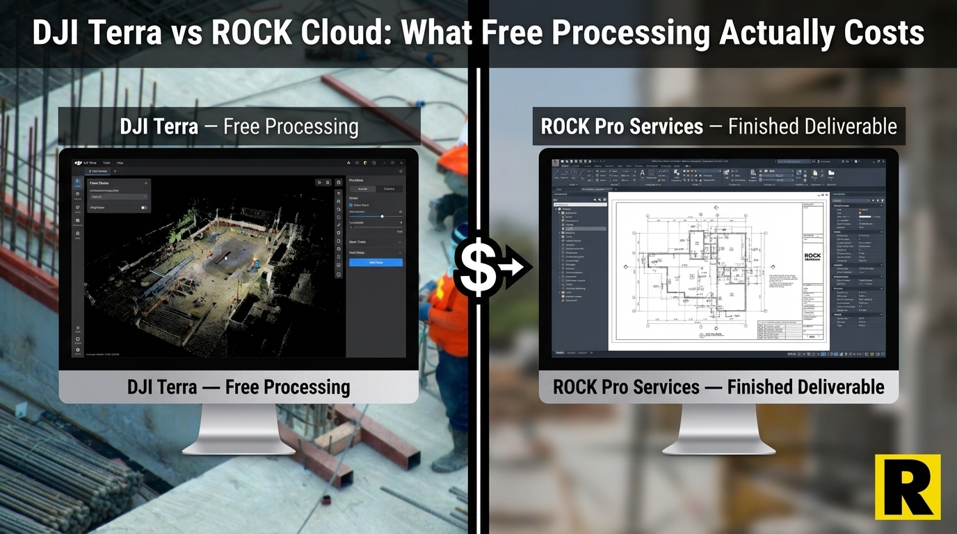
For a pilot who just wants a point cloud to look at, or a project where a colorized mesh is the deliverable, Terra does exactly what it needs to.
The problem is that most professional survey projects don't end at the point cloud. They end at a CAD file on a client's screen.
The Gap Between Point Cloud and Deliverable
Here is the workflow that DJI Terra handles:
Raw data → georeferenced point cloud ✅
Here is the workflow that your client actually needs:
Georeferenced point cloud → [manual labor] → classified ground surface → [more manual labor] → breaklines drafted → [more manual labor] → contours generated and cleaned → [more manual labor] → planimetric features digitized in CAD → [QA/QC] → CAD file delivered to client
That gap between "point cloud" and "CAD file" is where the real cost lives — and DJI Terra doesn't cross it.
What that gap looks like in practice for a 50-acre commercial site:
Ground classification cleanup: Terra's automated classification is a good starting point. But every experienced LiDAR processor knows what happens next — you zoom in and start finding problems. Low vegetation misclassified as ground. Bridge decks sitting in the ground class. Dense brush areas where the algorithm gave up. Building edges bleeding into terrain.
Manual cleanup: 4-8 hours.
Breakline drafting: Contours generated from a raw classified surface look jagged and artifact-heavy. Survey-grade contours require hand-drafted breaklines along curbs, ridges, ditches, retaining wall tops and bottoms, and water edges. This is almost entirely manual work.
Breakline drafting: 4-8 hours.
Planimetric extraction: Every building footprint, curb line, paint stripe, fence, utility pole, sign, and feature class your client needs has to be digitized by hand in CAD. There is no algorithm that does this reliably at survey-grade accuracy.
Planimetric digitization: 15-40 hours, depending on feature density.
QA/QC: Checking connectivity, layer assignments, missed features, classification errors. Your name is on the deliverable.
QA/QC: 2-6 hours.
Total for a 50-acre commercial site: 25-60+ hours of skilled technician time.
At $40-80/hour for a CAD technician or LiDAR analyst, that's $1,000-$4,800 in labor — per project.
The Terra Compute Problem
There's one more cost that doesn't show up in the software price: the workstation.
DJI recommends 64 GB RAM and an NVIDIA RTX 3080 for L3 data processing. A workstation meeting those specs costs $4,000-$6,000 new. It needs upgrading every 3-4 years as datasets get larger. It needs IT support. And when you land a large corridor project — hundreds of gigabytes of L3 data — even a capable workstation may need you to tile, process, and stitch the data back together.
The "free" Terra processing requires a significant hardware investment to actually run.
What ROCK Cloud + Pro Services Actually Costs
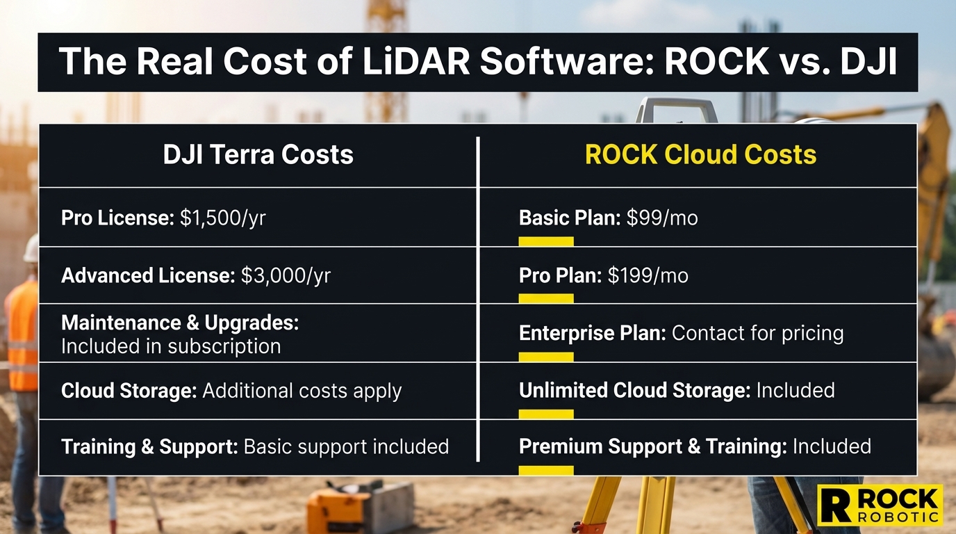
ROCK Cloud runs at $3,500/year. No workstation required — it runs in any browser, on any device, from the field.
ROCK Pro Services pricing is per-project and per-deliverable:
- ROCK Surveyor (bare earth, DTM, contours): $3-10/acre
- ROCK Planimetrics (full feature extraction, CAD-ready): $15-50+/acre
- ROCK PLS-CADD (utility corridor deliverables): custom pricing
For that same 50-acre commercial site:
- ROCK Surveyor: ~$150-500 for DTM + contours
- ROCK Planimetrics: ~$750-2,500 for full planimetric extraction
- Your time: 30 minutes (upload + order + review)
The deliverable arrives in ~24 hours, QC'd by licensed surveyors, in your CAD layer template.
The Full Cost Comparison
| Cost Category | DJI L3 + Terra | ROCK System + Cloud + Pro Services |
|---|---|---|
| Processing software | Free (L3 license) | ROCK Desktop (included Year 1) |
| Cloud platform | None | ROCK Cloud: $3,500/year |
| Workstation | $4,000–$6,000 | $0 — any browser |
| Technician labor (50-acre commercial, per project) | 25-60 hrs × $50/hr = $1,250–$3,000 | $0 in-house labor |
| Pro Services cost (50-acre commercial) | $0 (you do it yourself) | $150–$2,500 depending on deliverables |
| Year 1 total (10 projects, 50 acres each) | $4,000 workstation + $12,500-$30,000 labor = $16,500–$34,000 | $3,500 Cloud + $1,500-$25,000 Pro Services = $5,000–$28,500 |
At 10 projects with full planimetric deliverables, ROCK's total is competitive — and ROCK's output is ready for a client to use. Terra's output requires weeks of in-house production work to get there.
Hardware Lock-In
DJI Terra only works with DJI sensor data. If you add a non-DJI sensor to your fleet — a ROCK Ultra, a GeoCue TrueView, a YellowScan — Terra is irrelevant.
ROCK Cloud accepts standard LAS/LAZ point cloud files from any sensor. You can use it with DJI data. You can use it with GeoCue data. You can use it with a terrestrial scanner output. The platform doesn't care what collected the data — it cares about getting you to a deliverable.
What Terra Is Actually Good For
To be direct: DJI Terra is a good sensor-processing tool for DJI hardware users. If you're capturing data with a Zenmuse L3 and the deliverable is a colorized point cloud, a mesh, or a Gaussian Splat, Terra does that well.
Where Terra ends — at the point cloud — is exactly where ROCK Cloud + Pro Services begins.
The question isn't which software is better. The question is: what does your client actually need at the end of the project? If the answer is a CAD file, Terra gets you halfway there. ROCK gets you all the way.