Choosing the Best Drone for LiDAR Mapping in 2025
Aug 05, 2025
Drone-based LiDAR mapping has revolutionized how surveyors and GIS professionals collect topographic data. To get the most out of LiDAR in 2025, it’s crucial to choose a drone platform that can safely carry the LiDAR sensor, fly long enough to cover your project area, and meet any regulatory requirements (like NDAA compliance). In this article, we’ll compare three leading multirotor drones for LiDAR mapping – the DJI Matrice 350 RTK, Inspired Flight IF800 Tomcat, and Freefly Astro Max – including considerations around the U.S. NDAA/Blue UAS regulations. We’ll also discuss pairing these drones with high-performance LiDAR payloads (specifically, the ROCK Ultra and ROCK R3 Pro V2 scanners) to achieve the best mapping results.
Key Factors When Choosing a LiDAR Drone
Before diving into the drone comparisons, it’s important to understand some key factors that determine the “best” drone for LiDAR mapping:
- Payload Capacity & Stability: LiDAR sensors, plus their required cameras and mounting hardware, can weigh 1–3 kg or more. The drone must handle this weight comfortably – if a drone is at its limit just trying to lift the LiDAR, it will struggle to fly stably and your data quality will suffer. Always check that the drone’s max payload exceeds your LiDAR system weight (including GNSS, camera, etc.), and factor in some margin for safe flying.
- Flight Time & Area Coverage: Multirotor drones have limited flight endurance, especially under heavy payload. A larger battery capacity (or more efficient platform) means fewer flights to cover a given area. Fixed-wing UAVs generally fly faster and longer, making them better for very large or linear surveys, but multirotors are often preferred for LiDAR due to their ability to hover and maneuver in tight spaces. With multirotors, expect effective flight times on the order of 15–30 minutes with a LiDAR attached (even if the spec says “55 minutes” with no payload). This will determine how many acres you can scan per flight.
- Altitude & Field of View: Flying higher increases your swath (ground coverage) per pass, improving productivity – but it also reduces point density and accuracy if the LiDAR isn’t powerful enough. Each LiDAR sensor has a recommended max altitude for mapping (often 50–120 m AGL for drones). Using a high-performance LiDAR (discussed later) can let you fly at legal limits (120 m/400 ft AGL in many countries) without compromising data quality. Also note the LiDAR’s Field of View (FOV) – some scanners spread points in a wide 360° circle (wasting many points to the sides/sky), whereas others concentrate the FOV downward which can yield denser coverage on the ground.
- Drone Autonomy & Power: Heavier payloads and faster speeds drain batteries quickly. Consider drones with higher-capacity batteries or features like hot-swappable packs for minimal downtime. Also, the drone should have a sufficient power-to-weight ratio – flying near maximum throttle continuously to carry a load is not safe. For example, pairing a DJI M600 (older model) with a very heavy LiDAR might only get ~15 minutes flight. Newer drones have improved efficiency to maximize flight time even with LiDAR onboard.
- Terrain and Obstacles: Think about the typical environment – if you map in steep or forested areas, a nimble multirotor is essential (a fixed-wing might struggle near slopes or require large clearings to launch). Multirotors can take off and land in confined spots and handle vertical terrain changes more easily. Many mapping drones now have terrain-following and obstacle avoidance, but flying higher (if your LiDAR allows it) is an even safer way to clear trees and powerlines.
- NDAA Compliance (Blue UAS): This has become a deciding factor for many U.S. government-funded projects. The National Defense Authorization Act (NDAA) effectively bans using federal funds to procure or operate drones from “covered” foreign entities (notably Chinese UAVs) after 2025. Additionally, agencies often require drones on the DoD’s “Blue UAS” cleared list, which certifies platforms for cybersecurity and supply-chain integrity. In practice, this means many public agencies and universities can no longer buy DJI drones, despite their popularity. If NDAA compliance is a concern, you’ll need to opt for a U.S.-manufactured drone that meets these requirements (as we’ll see with the IF800 Tomcat and Astro Max).
With these factors in mind, let’s compare our three drone contenders for LiDAR mapping in 2025.
Comparing Top LiDAR Mapping Drones in 2025
DJI Matrice 350 RTK (M350)
The M350 offers robust performance: up to 55 minutes of flight time (with no payload) and a maximum payload of ~2.7 kg. In real-world LiDAR use, carrying a ~1–2 kg sensor, users often see 25–30 minute flight durations, which is plenty to cover medium-sized sites in one mission. DJI’s ecosystem is a major selling point – the M350 supports multiple payloads simultaneously and seamlessly integrates with DJI’s cameras (e.g. Zenmuse P1). Mounting third-party sensors like ROCK LiDAR is plug-and-play via the DJI SkyPort adapter.
However, the M350 is not NDAA-compliant, since DJI is a Chinese manufacturer. U.S. government and many commercial contracts now prohibit using Chinese-made drones. This limitation means that while the M350 remains a fantastic tool for private surveying firms (with its proven hardware and DJI’s advanced flight software), it often cannot be used on projects involving federal funds or sensitive infrastructure. Aside from the compliance issue, the M350 RTK is considered a workhorse: IP55 weather-rated, 6-directional obstacle sensing, 20 km video link, and support for advanced features in DJI Pilot software. Its cost (~$12–14k for the drone) and global support network also make it an attractive choice if regulations allow.
Inspired Flight IF800 Tomcat
The IF800 is a medium-lift UAV that can carry up to 6.6 lbs (3.0 kg) of payload while still achieving long flight times – up to ~54 minutes per mission in ideal conditions. This endurance is aided by its dual hot-swappable batteries, meaning you can land and swap packs one at a time without powering down the drone. In practice with a typical LiDAR (1–2 kg) you might expect 30–40+ minutes of flight, which often outlasts the DJI M350 under similar load. The IF800’s frame folds for transport and is built tough, withstanding ~23 knot winds (~12 m/s) so you can map in less-than-perfect weather. It has a top speed around 49 mph, useful for quickly transecting large sites or long corridors.
Crucially, Inspired Flight drones are NDAA-compliant and on the Blue UAS cleared list (the IF800 is manufactured and supported entirely in the USA). This makes the IF800 Tomcat a go-to platform for government agencies or universities that can’t use DJI. It runs an open-source ArduPilot flight controller, which gives it flexibility and extensibility (though it may not have the polished UI of DJI Pilot). For payloads, Inspired Flight provides a universal payload interface and has pre-integrated support for many sensors – whether it’s a 61 MP Sony mapping camera or a LiDAR unit, you can easily attach and control it. The IF800’s “Smart Dovetail” quick-release system and open architecture are analogous to Freefly’s (discussed next), emphasizing versatility. Overall, the IF800 Tomcat is a high-end solution that trades some of DJI’s ease-of-use for longer endurance and compliance. It tends to be priced higher than the DJI (reflecting its domestic manufacturing and low-volume enterprise market). But for those who need it, the IF800 delivers a reliable, Blue UAS-approved workhorse for LiDAR mapping missions.
Freefly Astro Max
Freefly Systems is known for high-end drones and gimbals (with roots in Hollywood cinematography), and the Astro Max is their latest mapping drone as of 2025. It’s an NDAA-compliant, Blue UAS-listed quadcopter similar in class to the IF800 – in fact Freefly specifically upgraded the Astro to the “Max” variant to achieve a 3 kg (6.6 lb) payload capacity, matching the IF800. With stronger motors and 60% more thrust than the original Astro, the Max can carry heavy LiDAR sensors or dual payloads. Its flight time is about 18 minutes with the full 3 kg load, and up to ~28 minutes with a lighter payload like a camera (maximum ~39 minutes with no payload for ferrying). While its endurance with LiDAR is a bit less than the IF800’s, the Astro Max offers other advantages. It uses hot-swappable “SL8” batteries (similar concept to IF800) and features an Auterion Skynode flight controller, which provides RTK GPS and optional LTE connectivity for cloud-based mission control.
Freefly prides itself on a refined user experience: the Astro Max comes with the Pilot Pro handheld controller (with an 8″ screen tablet integrated) and an open Smart Dovetail payload mount. This dovetail system supplies power/data and makes it easy to swap sensors (LiDAR, RGB, thermal, multispectral, etc.) without any rewiring. For example, you might fly a LiDAR scanner on one flight, then slide in a 61 MP photogrammetry camera for an orthophoto on the next – the drone recognizes the payload and you’re ready to go. In terms of size, the Astro Max is highly portable: it folds down to half its span, fitting in a carry-on sized case. It’s built and tested in Washington, USA, adhering to strict quality control (each unit goes through in-house environmental and flight testing). The Astro Max’s price point is around $26k for a bundle, positioning it at the premium end. For that, you get a state-of-the-art Blue UAS platform that is “ready to work” out of the box for mapping, inspection, or public safety missions. In summary, Freefly’s Astro Max provides a compact yet powerful alternative to the IF800 – with slightly shorter flight endurance, but a very polished ecosystem and integration. It’s an ideal choice for enterprise users who need compliance and a flexible, professional-grade drone.
Drone Comparison Summary:
All three drones above can lift modern lightweight LiDAR sensors (typically 1–2.5 kg) and perform mapping missions with high reliability. The DJI M350 RTK shines in flight time and cost-efficiency for those not constrained by NDAA rules, and benefits from DJI’s mature software integration. The Inspired Flight IF800 and Freefly Astro Max are the leading NDAA-compliant options – both offering similar payload capacity (3 kg) and advanced features. The IF800 edges ahead in raw flight endurance, whereas the Astro Max offers a very user-friendly package and ecosystem. Your choice may boil down to regulatory necessity (DJI vs Blue UAS) and the scale of your projects (if you need every extra minute aloft, IF800’s larger batteries could be beneficial).
Next, we’ll consider the LiDAR payloads themselves – since the “best drone” is only half of the equation in LiDAR mapping.
Choosing the Right LiDAR Payload: ROCK Ultra vs. ROCK R3 Pro V2
Equally important to the drone platform is the LiDAR sensor you put on it. In 2025, two cutting-edge LiDAR systems that often come up as “payloads of choice” are the ROCK Ultra and ROCK R3 Pro V2 from ROCK Robotic. Each is designed for survey-grade mapping but with different strengths. Here’s how they compare and complement the drones we discussed:
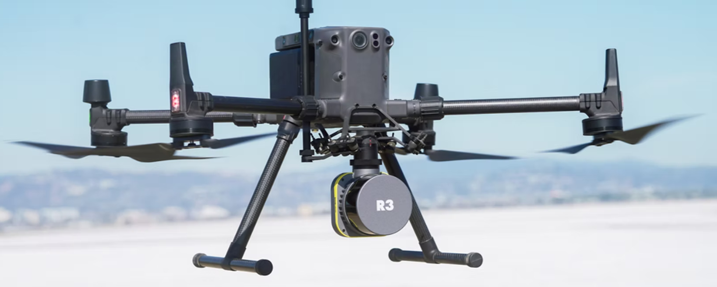
- ROCK Ultra LiDAR – Maximum Range and Efficiency: The ROCK Ultra is a next-generation 1550 nm airborne LiDAR system built to break the traditional limits of drone LiDAR. It uses a Class 1 eye-safe laser that reaches extremely far – up to 1000 m range on high-reflectivity targets – which translates to practical operating altitudes of 120–150 m AGL (400–500 ft) while still achieving survey-grade accuracy. This means you can legally fly at the max altitude (for the U.S., 400 ft) and cover massive swaths of ground in one pass. The Ultra directs 1,000,000 laser pulses per second in a 90° downward FOV, concentrating all points on the ground surface for dense coverage. Uniquely, it captures up to 7 return echoes per pulse, allowing it to “see” through layers of foliage and reliably hit the true ground in heavy vegetation. In the field, this results in point clouds rich with detail – operators report clearly mapping features like narrow power lines, curbs, and creek beds from 120 m up, which used to require much lower flights. With its long range and downward focus, the ROCK Ultra can cover hundreds of acres in a single flight, greatly boosting efficiency (Rock Robotic estimates 2–3× more area covered per flight compared to typical 360° LiDAR scanners). By flying higher and faster, you also reduce the number of flight lines needed – one ROCK Ultra demo mapped ~100 acres in under four minutes of flight.Which drone for ROCK Ultra? Weighing ~1.4 kg (including its optional camera), the ROCK Ultra is well within the payload capacity of the M350, IF800, or Astro Max. In fact, part of its design is an easy integration with DJI SkyPort gimbal mounts for the M300/M350 series. On a DJI M350 RTK, the Ultra truly becomes an “easy button” for large surveys – you can fly at 120 m AGL, above most obstacles, simplifying your mission planning while still collecting dense data. Users flying the Ultra on Blue UAS platforms (like the IF800 or Astro) have similarly reported tremendous gains in productivity, because they can scan broad areas from a safe altitude without multiple grid flights. In dense forests or rugged terrain, the Ultra’s 7 returns are especially valuable – when mounted on an IF800 or Astro Max, you have a combo that can penetrate tree canopy and map the forest floor in detail, all while keeping the drone high enough to avoid terrain hazards. In short, the ROCK Ultra is the ideal payload for large-area and high-altitude LiDAR mapping – if your projects involve thousands of acres, powerline corridors, floodplains, or tall forests, pairing an Ultra with a capable drone (DJI or NDAA-approved) will give you unparalleled efficiency and data quality.
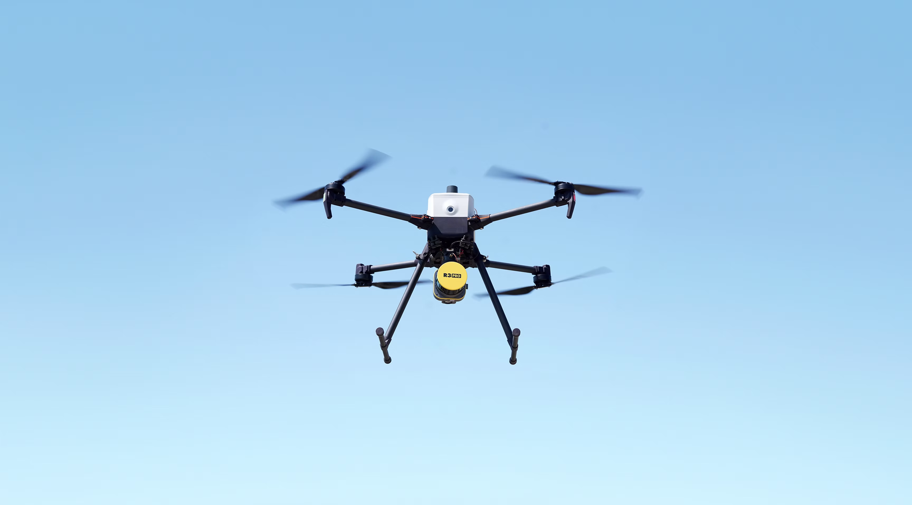
- ROCK R3 Pro V2 LiDAR – Versatility and Precision: The ROCK R3 Pro V2 takes a different approach – it’s all about multi-mission flexibility. The R3 Pro V2 uses a 905 nm Hesai Pandar XT32 sensor (32 laser channels) which spins 360° and fires up to 1.28 million points/sec (with dual returns). It doesn’t have the extreme range of the Ultra, instead it’s optimized for mid-altitude drone flights (~50 m AGL) and also for use on vehicles or handheld. In drone mode, the R3 Pro V2 can achieve 2–3 cm accuracy in surveys (about 0.1 ft vertical precision) – easily meeting typical mapping requirements. Its range precision is ~5 mm, which means individual point measurements are very tight. The big advantage of the R3 Pro is its versatility: the same unit (about 1.26 kg weight) can be mounted on a DJI M300/M350 via SkyPort, or quickly moved to a car/ATV for mobile scanning, or used with a backpack/handheld kit in GNSS-denied areas. For example, you could fly a drone mission to capture a site’s terrain, then take the R3 Pro off the drone and walk through a building to scan interior details – all with one LiDAR system. This “3-in-1” capability (air, ground vehicle, handheld) is unique at this level. The R3 Pro V2’s LiDAR has a full 360° field of view, which means when airborne it captures not only directly below but all around the drone – useful for mapping vertical structures or dense urban environments. (It also means fewer “gaps” if the drone rolls or pitches, since the scanner covers the entire surroundings). When mounted on a vehicle, that 360° coverage is ideal for scanning roadside assets or building façades. Additionally, the R3 Pro V2 supports integration with SLAM (Simultaneous Localization and Mapping): with an add-on module, it can use its LiDAR data to self-localize indoors or under canopy where GPS is unavailable, and even capture 360° photos to colorize the point cloud.Which drone for R3 Pro V2? All three drones (M350, IF800, Astro) can carry the 1.26 kg R3 Pro V2 with ease. If your focus is strictly aerial mapping of large open areas, the Ultra might be more efficient; but if you need a more general-purpose mapping tool, the R3 Pro V2 is hard to beat. On a DJI M350, for instance, you could fly lower-altitude passes with the R3 Pro to get ultra-high point densities (its 32 channels can produce very rich point clouds at close range). On an IF800 or Astro, the R3 Pro could be a great choice for projects that involve a mix of tasks – say, a utility company that wants to map a substation from above, then drive along transmission lines, then walk through an underground vault. The R3 Pro V2 can handle all those scenarios. It also integrates with the same ROCK Cloud software ecosystem, meaning whether you collect data from the drone or on foot, you process it in one place. In summary, the ROCK R3 Pro V2 is the payload to choose if you value versatility and all-around scanning capability. It delivers high precision on drone surveys, while also giving you the option to extend your mapping to mobile and indoor applications – effectively future-proofing your investment in LiDAR hardware.
Conclusion
In 2025, choosing the best drone for LiDAR mapping comes down to matching the drone’s capabilities with your project needs (and ensuring compliance with any regulations), then pairing it with a LiDAR sensor that will deliver the required data quality. The DJI Matrice 350 RTK remains a top performer for many surveyors with its proven reliability, ample payload capacity, and seamless integration – a great choice where NDAA restrictions don’t apply. For those who need a secure, U.S.-made platform, the Inspired Flight IF800 Tomcat and Freefly Astro Max stand out as leading options, offering heavy payload support (3 kg) and sophisticated features on par with high-end DJI drones. Between those two, careful consideration of flight time vs. portability and ecosystem may guide your decision – but either will capably lift modern LiDAR units and satisfy Blue UAS requirements.
On the payload side, technologies like the ROCK Ultra LiDAR are pushing the envelope, allowing you to fly higher and map faster than ever before without sacrificing accuracy. If large-area efficiency is your priority, investing in such a high-performance LiDAR and a drone that can support it will pay dividends (imagine covering in a day what used to take three!). Meanwhile, the ROCK R3 Pro V2 exemplifies the versatility trend – one LiDAR system that you can deploy in the air or on the ground, adapting to whatever the job requires. This kind of flexibility can unlock new services (like indoor scans or mobile mapping) in addition to your aerial surveying.
In closing, the “best” drone for LiDAR mapping is the one that meets your technical needs and operational constraints. Assess the typical size of your projects, the terrain and environment, and any regulatory or client requirements. Then consider the drone platform and LiDAR sensor as an integrated solution. A balanced choice in 2025 might be, for example, an Astro Max drone with a ROCK Ultra payload for maximum coverage, or an IF800 Tomcat with a ROCK R3 Pro V2 for all-purpose deployment – or indeed a DJI with whichever payload fits if compliance isn’t an issue. By carefully aligning these components, you’ll be equipped to capture high-quality 3D data efficiently and safely, staying ahead in the rapidly evolving field of drone LiDAR mapping.