Ready to Master Your LiDAR Workflow?
The ROCK Academy will give you the knowledge and confidence to fly, capture, analyze, and process 3D LiDAR data using a seamless workflow developed by ROCK Robotic.
“By the end of this course, you will become a LiDAR master!” – Harrison Knoll (CEO, ROCK Robotic)
Mastering Your LiDAR Workflow: Curriculum
A comprehensive, end-to-end program covering field capture, preprocessing, and production of professional deliverables.
IIntroduction
Show
Introduction
Introducing ROCK Academy
RROCK R3 Pro
Show
ROCK R3 Pro
Introduction to the R3 Pro
A–Z Walkthrough: Overview
Setting-up the Base Station
Emlid Base Station Settings
Using Ground Control Points (GCPs) for Optimal LiDAR Data
DJI M600/M350 Damping Assembly Guide
Setting-up the DJI M300–M350
Installing the R3 Pro on DJI M300–M350
Mission Plan Preparation
Mission Planning
Powering on the R3 Pro
LiDAR Calibration Guide
Stop Collecting and Get Ready for ROCK Desktop
Operating the ROCK Pilot App
RRTK and GCPs
Show
RTK and GCPs
Understanding RTK with Emlid Base Station
Exploring Ground Control Points (GCPs)
Logging Static Observations (Reach RS2/RS2+)
RROCK Desktop
Show
ROCK Desktop
Introduction to ROCK Desktop
A–Z Walkthrough: Overview
Set-up and Activation
Computer Specs and Requirements
Retrieving Processing Data
Updating Software & Initiating Point Cloud Processing
Sensor Profiles
Setting Base Station Location
Selecting Flight Lines
Angle Gate “FoV”
Range Gate “Distance”
Reviewing Data in the Field
Camera Calibration
GCP Alignment Tool (SLAM/RS2)
RROCK SLAM
Show
ROCK SLAM
Introduction to ROCK SLAM
A–Z Walkthrough: Overview
Installing R3 Pro: ROCK SLAM
Capturing: Best Practices
Operating the R3 Pro with the Power Button
Pro Tip: Capturing Stairwells
Pro Tip: Going into Rooms
Generating a ROCK SLAM Point Cloud
Reviewing the ROCK SLAM Data
The Future of ROCK SLAM
RROCK Mobile Mount
Show
ROCK Mobile Mount
Installation & Best Practices
RROCK Cloud
Show
ROCK Cloud
Introduction to ROCK Cloud
Processing LiDAR Data: Starting a New Project
Navigating & Analyzing the Data
Data QC/QA & Alignment (GCPs)
Generating Deliverables (ROCK Surveyor)
Analyzing Deliverables (ROCK Surveyor)
Mastering Stockpile Volumetrics
Exploring Planimetrics (Linework)
Custom Planimetric Symbols
Adding Breaklines
48+
Lessons
100+
Resources
Field → Cloud
End-to-End Workflow
LiDAR + SLAM
Capture Methods
ROCK Cloud
Deliverables
Certificate
Completion
48+
Lessons, simplified to help you learn quickly
Workflow
Step-by-step process from capture to deliverables
Confidence
Build practical skills you can use immediately
Here's what you'll learn
Follow a proven workflow developed by ROCK Robotic, from field capture to final deliverables.
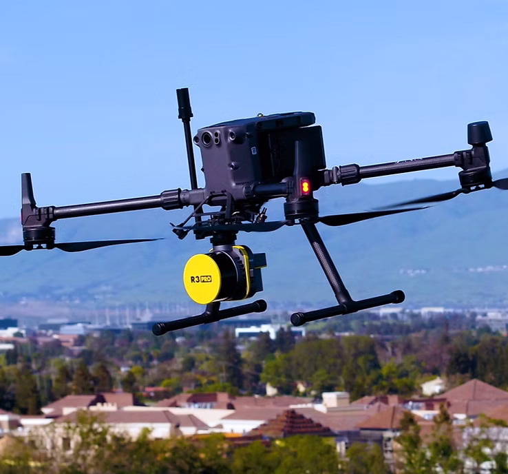
Fly Aerial Drone LiDAR (R3 Pro V2)
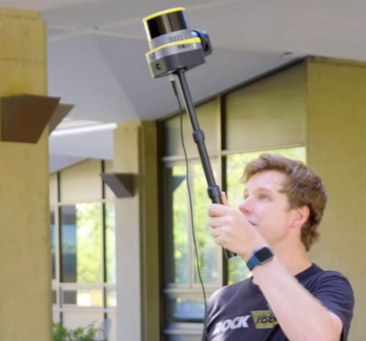
Handheld 3D Mapping with ROCK SLAM
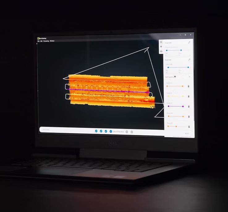
Visualize, Modify, & Process Raw Data
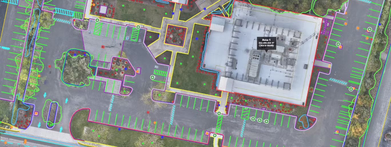
Get deliverables (ROCK Surveyor)
Structured lessons: bite-sized videos, checklists, and practice data for hands-on learning.
Real flight demos: best practices for mission planning, calibration, and QC.
Confidence to deliver: produce DTMs, contours, planimetrics, and more—accurately.
Course Curriculum
From field to finish—follow a step-by-step workflow using ROCK hardware, ROCK Desktop, and ROCK Cloud.
1. Foundations
- LiDAR basics & safety
- Coordinate systems & accuracy
- Project setup & data hygiene
2. Capture
- Aerial flight planning
- Handheld SLAM workflows
- Calibration & field QC
3. Processing
- ROCK Desktop preprocessing
- Noise filtering & alignment
- Colorization & export
4. Deliverables
- DTM & contours
- Planimetrics extraction
- Publishing in ROCK Cloud
Built for Geospatial Pros
Whether you are a land surveyor, drone services provider, or utility engineer, the academy equips you with a repeatable workflow that scales.
Land Surveyors
Produce survey-grade DTMs and contours with confidence in accuracy and repeatability.
DSPs & Mappers
Standardize capture, reduce revisits, and deliver polished results on tight deadlines.
Utilities & AEC
Create actionable deliverables for asset management, design, and encroachment analysis.
What’s Included
- Downloadable checklists and mission templates
- Practice datasets for aerial and SLAM workflows
- ROCK Desktop project files and presets
- Post-processing guides for accuracy and alignment
- Deliverables best practices: DTM, contours, planimetrics
- Certificate of completion
“Our company has been working with ROCK Robotic for nearly a year and we have been amazed at the rapid turnaround, attention to detail, continuous added features and the courtesy and knowledge of their support staff. ROCK Robotic becomes part of your team.”
Michael Elliott — Drone Services Hawaii
Frequently Asked Questions
How long does the academy take to complete?
Most learners complete the core modules in 1–2 weeks part-time. You can move at your own pace and return anytime to refresh.
Do I need a ROCK system to take the course?
No. While we use ROCK hardware and software in demonstrations, the core LiDAR and SLAM concepts apply broadly. Practice datasets are included.
Will this help me produce survey-grade deliverables?
Yes. The workflow emphasizes calibration, control, and QC required to produce accurate DTMs, contours, and planimetrics.
Is there a certificate of completion?
Yes. You’ll receive a digital certificate after completing the final module and knowledge check.
What if I get stuck?
Your enrollment includes access to our community and support resources—plus optional 1-on-1 onboarding sessions.
Master a Complete LiDAR Workflow
Professional LiDAR is more than a sensor—it is a disciplined, end‑to‑end process. The ROCK Academy teaches repeatable methods for mission planning, data capture, preprocessing in ROCK Desktop, and generating client‑ready deliverables in ROCK Cloud. You will learn how to validate accuracy, mitigate drift, manage coordinate systems, and communicate results to stakeholders.
Aerial and Handheld—One Cohesive Curriculum
The course covers both aerial LiDAR (R3 Pro V2) and handheld SLAM capture so you can choose the right tool for the job—or combine them in hybrid projects. Practical examples show how to align datasets, remove artifacts, and extract planimetrics with confidence.
From Raw Points to Actionable Deliverables
You will produce deliverables that clients actually use: classified point clouds, ground models, contour maps, and CAD‑ready vector linework. We emphasize QC at every step to ensure defensible results—because professional mapping demands more than pretty pictures.
Enroll now and start your journey to LiDAR mastery
Join the ROCK Academy and learn the complete workflow from capture to deliverables.